IMAGES TAKEN NEAR TO
Brightlingsea Road, SANDWICH, CT13 0QN
Introduction
This page details the photographs taken nearby to Brightlingsea Road, CT13 0QN by members of the Geograph project.
The Geograph project started in 2005 with the aim of publishing, organising and preserving representative images for every square kilometre of Great Britain, Ireland and the Isle of Man.

There are currently over 7.5m images from over14,400 individuals and you can help contribute to the project by visiting https://www.geograph.org.uk
Image Map
Images are licensed for reuse under creativecommons.org/licenses/by-sa/2.0
Notes
- Clicking on the map will re-center to the selected point.
- The higher the marker number, the further away the image location is from the centre of the postcode.
Image Listing (170 Images Found)
Images are licensed for reuse under creativecommons.org/licenses/by-sa/2.0
Image
Details
Distance
1
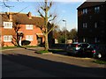
The end of Jubilee Road from Boatman's Hill cemetery
Image: © Nick Smith
Taken: 8 Feb 2008
0.04 miles
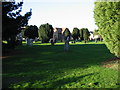
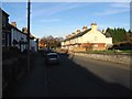
4

Boatmans Hill Cemetery
Seen across Woodnesborough Road, the cemetery chapel bears the date 1855.
Image: © John Baker
Taken: 30 Oct 2013
0.10 miles

6
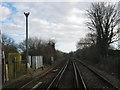
Railway to Sandwich
As seen from Image This line leads from Ramsgate, towards Sandwich, before heading to Deal and Dover.
Image: © David Anstiss
Taken: 16 Jan 2011
0.11 miles
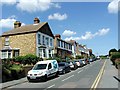
7

Houses on Sandwich Road from Boatman's Hill cemetery
Image: © Nick Smith
Taken: 8 Feb 2008
0.11 miles
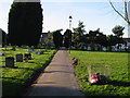
10
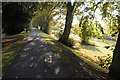
The Rope Walk, Sandwich
This path follows the course of the former Sandwich town wall.
Image: © Philip Halling
Taken: 16 Oct 2011
0.12 miles