IMAGES TAKEN NEAR TO
The Aireys, SANDWICH, CT13 0QD
Introduction
This page details the photographs taken nearby to The Aireys, CT13 0QD by members of the Geograph project.
The Geograph project started in 2005 with the aim of publishing, organising and preserving representative images for every square kilometre of Great Britain, Ireland and the Isle of Man.

There are currently over 7.5m images from over14,400 individuals and you can help contribute to the project by visiting https://www.geograph.org.uk
Image Map
Images are licensed for reuse under creativecommons.org/licenses/by-sa/2.0
Notes
- Clicking on the map will re-center to the selected point.
- The higher the marker number, the further away the image location is from the centre of the postcode.
Image Listing (90 Images Found)
Images are licensed for reuse under creativecommons.org/licenses/by-sa/2.0
Image
Details
Distance
1
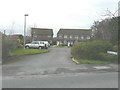
The Airey's, Woodnesborough
A small cul-de-sac of houses off Foxborough Hill.
Image: © John Baker
Taken: 30 Dec 2012
0.01 miles
2

Land between 15 & 17 Foxborough Close
Planning permission has been granted by Dover District Council under application number DOV/21/00188 for the “erection of 2 semi-detached dwellings with vehicular access and associated parking”.
Image: © John Baker
Taken: 9 May 2021
0.03 miles
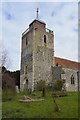
3
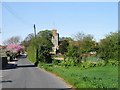
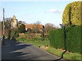
Woodnesborough Church and Foxborough Hill
Image: © Nick Smith
Taken: 20 Apr 2007
0.03 miles
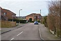
5
Foxborough Close, Woodnesborough
Is a cul-de-sac off Foxborough Hill, which it shares with St Mary's Close.
Image: © John Baker
Taken: 30 Dec 2012
0.04 miles
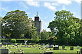
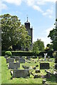
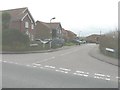
10
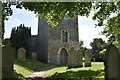
Woodnesborough church
Autumnal view of Image The Parish Church of St. Mary with its unique wooden tower in place of a spire that was removed in 1745. It is topped by a cupola, a feature rarely found in England, this may be due to Dutch influence (many had settled in the Sandwich area, escaping religious persecution). (Text taken from the "Open Sandwich" web site)
Image: © Nick Smith
Taken: 1 Dec 2007
0.05 miles