IMAGES TAKEN NEAR TO
Farm Lane, SANDWICH, CT13 0PJ
Introduction
This page details the photographs taken nearby to Farm Lane, CT13 0PJ by members of the Geograph project.
The Geograph project started in 2005 with the aim of publishing, organising and preserving representative images for every square kilometre of Great Britain, Ireland and the Isle of Man.

There are currently over 7.5m images from over14,400 individuals and you can help contribute to the project by visiting https://www.geograph.org.uk
Image Map
Images are licensed for reuse under creativecommons.org/licenses/by-sa/2.0
Notes
- Clicking on the map will re-center to the selected point.
- The higher the marker number, the further away the image location is from the centre of the postcode.
Image Listing (65 Images Found)
Images are licensed for reuse under creativecommons.org/licenses/by-sa/2.0
Image
Details
Distance
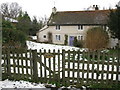
4
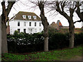
Marshborough House
At the end of a little lane off Marshborough Road
Image: © Nick Smith
Taken: 11 Jan 2010
0.02 miles
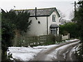
5
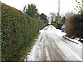
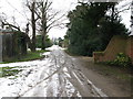
View along lane towards Marshborough Farm
Image: © Nick Smith
Taken: 11 Jan 2010
0.02 miles
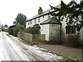
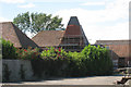
8
The Garth, Marshborough
One of many pretty little houses and cottages in this hamlet.
Image: © Nick Smith
Taken: 11 Jan 2010
0.04 miles
9
View SW along lane from Marshborough Farm
Image: © Nick Smith
Taken: 11 Jan 2010
0.04 miles
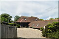
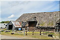
10
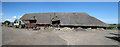
Thatched Barn at Marshborough Farm
Impressive grade II listed eight aisled barn.
Image: © Oast House Archive
Taken: 22 Jul 2010
0.04 miles