IMAGES TAKEN NEAR TO
Poulders Road, SANDWICH, CT13 0LX
Introduction
This page details the photographs taken nearby to Poulders Road, CT13 0LX by members of the Geograph project.
The Geograph project started in 2005 with the aim of publishing, organising and preserving representative images for every square kilometre of Great Britain, Ireland and the Isle of Man.

There are currently over 7.5m images from over14,400 individuals and you can help contribute to the project by visiting https://www.geograph.org.uk
Image Map
Images are licensed for reuse under creativecommons.org/licenses/by-sa/2.0
Notes
- Clicking on the map will re-center to the selected point.
- The higher the marker number, the further away the image location is from the centre of the postcode.
Image Listing (7 Images Found)
Images are licensed for reuse under creativecommons.org/licenses/by-sa/2.0
Image
Details
Distance
1
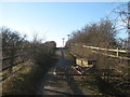
Poulder Road ends
Poulder Road, is a farm access road that leads to Great Poulder Farm from Woodnesborough Road. A footpath carries on over a bridge (over the A256 Ramsgate Road).
Image: © David Anstiss
Taken: 16 Jan 2011
0.06 miles
2
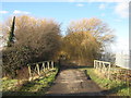
Poulders Road
This farm road leads from Woodnesborough Road towards Great Poulders Farm.
It passes through an avenue of willow trees. This road is also a footpath leading to the farm and onwards to Marshborough.
In the foreground is a footbridge over South Poulders Stream.
Image: © David Anstiss
Taken: 16 Jan 2011
0.08 miles
3
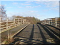
Bridge over the A259 Ramsgate Road
A farm bridge leads over the busy A road, towards Great Poulder Farm.
This is also used by a footpath leading from Marshborough to Sandwich, via the farm.
Image: © David Anstiss
Taken: 16 Jan 2011
0.09 miles
4
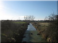
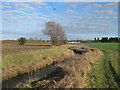
South Poulders Stream, looking upstream
As seen from Poulders Road, a farm road leading to Great Poulders Farm.
This stream leads from Marshborough through the marshland near Sandwich towards the River Stour.
Image: © David Anstiss
Taken: 16 Jan 2011
0.12 miles
5
South Poulders Stream
As seen from a footpath near Sandwich. This stream leads through the marshland near Sandwich towards the River Stour.
Image: © David Anstiss
Taken: 16 Jan 2011
0.18 miles
6
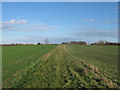
Farm track near Marshborough Farm
A footpath from Marshborough Farm leads across a field and then along a track towards a bridge over the A256 Ramsgate Road. Then it passes Great Poulder Farm before heading towards Sandwich.
Image: © David Anstiss
Taken: 16 Jan 2011
0.21 miles
7
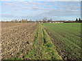
Footpath to Sandwich
A footpath from Marshborough passes through Great Poulders Farm, then it leads towards the caravan park near Woodnesborough Road in Sandwich.
Image: © David Anstiss
Taken: 16 Jan 2011
0.23 miles