IMAGES TAKEN NEAR TO
Maymills, Mill Lane, SANDWICH, CT13 0LB
Introduction
This page details the photographs taken nearby to Maymills, Mill Lane, CT13 0LB by members of the Geograph project.
The Geograph project started in 2005 with the aim of publishing, organising and preserving representative images for every square kilometre of Great Britain, Ireland and the Isle of Man.

There are currently over 7.5m images from over14,400 individuals and you can help contribute to the project by visiting https://www.geograph.org.uk
Image Map
Images are licensed for reuse under creativecommons.org/licenses/by-sa/2.0
Notes
- Clicking on the map will re-center to the selected point.
- The higher the marker number, the further away the image location is from the centre of the postcode.
Image Listing (83 Images Found)
Images are licensed for reuse under creativecommons.org/licenses/by-sa/2.0
Image
Details
Distance
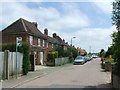
4

Houses on West side of Lower Street.
West side of Lower Street viewed from property on East side.
Image: © Nick Smith
Taken: 4 May 2006
0.06 miles
5
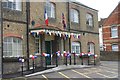
Eastry Village Hall
Village Hall, decorated for Twinning weekend. Formerly an Engineering works.
Image: © Nick Smith
Taken: 7 May 2006
0.06 miles
6
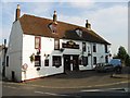
The 5 Bells Public House
May be renamed if the church gets another bell.
Image: © Nick Smith
Taken: 15 Jun 2003
0.06 miles
7
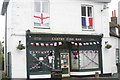
Eastry Fish Bar
Decorated for the Twinning weekend.
Image: © Nick Smith
Taken: 7 May 2006
0.06 miles
8
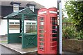
Telephone box and bus shelter, Eastry
Telephone box and bus shelter on E of the High street.
Image: © Nick Smith
Taken: 7 May 2006
0.06 miles