IMAGES TAKEN NEAR TO
High Street, SANDWICH, CT13 0HF
Introduction
This page details the photographs taken nearby to High Street, CT13 0HF by members of the Geograph project.
The Geograph project started in 2005 with the aim of publishing, organising and preserving representative images for every square kilometre of Great Britain, Ireland and the Isle of Man.

There are currently over 7.5m images from over14,400 individuals and you can help contribute to the project by visiting https://www.geograph.org.uk
Image Map
Images are licensed for reuse under creativecommons.org/licenses/by-sa/2.0
Notes
- Clicking on the map will re-center to the selected point.
- The higher the marker number, the further away the image location is from the centre of the postcode.
Image Listing (239 Images Found)
Images are licensed for reuse under creativecommons.org/licenses/by-sa/2.0
Image
Details
Distance
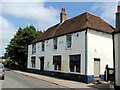
2
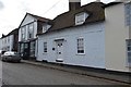
The Bull Inn, Eastry
A grade II listed building, is seems to be closed as a pub, but oddly only a door is boarded up.
Image: © Robin Webster
Taken: 12 Jun 2014
0.01 miles
4
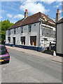
Relaying roof tiles, The Bull Inn, 7 High Street
Dover District Council granted two planning applications in relation to this building. DOV/14/00441 was the “change of use and conversion to single residential dwelling” and DOV/14/00441 was the “conversion to a single residential dwelling and associated internal alterations” (this application was related to listed building consent).
The former public house is a grade II listed building that dates from the early 18th century with an earlier core but was altered in the mid 19th century. The listing also includes the rear courtyard that is connected to the building by a single storey brick range
http://www.britishlistedbuildings.co.uk/en-178173-the-bull-inn-and-rear-courtyard-eastry-k#.VX3G__7bLcc
Image: © John Baker
Taken: 17 May 2015
0.01 miles
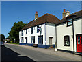
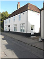
5
Conversion of the Bull Inn, 7, High Street
Compared with Image, now that the retiling of the roof has been completed, work is being carried out to the exterior walls.
Dover District Council granted two planning applications in relation to this building. DOV/14/00441 was the “change of use and conversion to single residential dwelling” and DOV/14/00441 was the “conversion to a single residential dwelling and associated internal alterations” (this application was related to listed building consent).
The former public house is a grade II listed building that dates from the early 18th century with an earlier core but was altered in the mid 19th century. The listing also includes the rear courtyard that is connected to the building by a single storey brick range
http://www.britishlistedbuildings.co.uk/en-178173-the-bull-inn-and-rear-courtyard-eastry-k#.VX3G__7bLcc
Image: © John Baker
Taken: 23 Aug 2015
0.01 miles
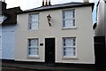
6
The Bull, 7 High Street
Compared with Image, a small plaque has been affixed to the right of the front door with the (new) name of the house and a date of AD1573.
Image: © John Baker
Taken: 2 Oct 2016
0.01 miles
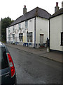
7
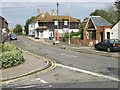
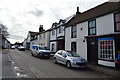
Eastry High Street from the junction with Mill Lane
Image: © Nick Smith
Taken: 29 Sep 2007
0.01 miles
8
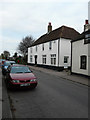
Former Bull Inn, 7 High Street
This is how the Image appeared before the exterior had been repainted.
The former public house is a grade II listed building that dates from the early 18th century with an earlier core but was altered in the mid 19th century. The listing also includes the rear courtyard that is connected to the building by a single storey brick range http://www.britishlistedbuildings.co.uk/en-178173-the-bull-inn-and-rear-courtyard-eastry-k#.Volxh8Lnncd
Image: © John Baker
Taken: 2 Dec 2015
0.01 miles