IMAGES TAKEN NEAR TO
St. Bartholomews, SANDWICH, CT13 0BP
Introduction
This page details the photographs taken nearby to St. Bartholomews, CT13 0BP by members of the Geograph project.
The Geograph project started in 2005 with the aim of publishing, organising and preserving representative images for every square kilometre of Great Britain, Ireland and the Isle of Man.

There are currently over 7.5m images from over14,400 individuals and you can help contribute to the project by visiting https://www.geograph.org.uk
Image Map
Images are licensed for reuse under creativecommons.org/licenses/by-sa/2.0
Notes
- Clicking on the map will re-center to the selected point.
- The higher the marker number, the further away the image location is from the centre of the postcode.
Image Listing (132 Images Found)
Images are licensed for reuse under creativecommons.org/licenses/by-sa/2.0
Image
Details
Distance
1
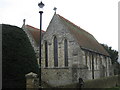
St. Bart's Chapel, Sandwich
Grade I Listed Church within St.Bartholomew's Hospital grounds.
St.Bart's is one of the oldest established hostels for travellers and pilgrims, dating back possibly, to 1190. The Chapel is still used for various functions.
See http://www.open-sandwich.co.uk/town_history/ancient_hospitals.htm for more details on the hospital and chapel.
See also http://www.britishlistedbuildings.co.uk/en-177376-st-bartholomews-chapel-sandwich for more details about the building.
Image: © David Anstiss
Taken: 13 Feb 2011
0.02 miles
2
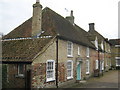
Three of the 16 houses of St. Bartholomew's Hospital
The hospital (on Dover Road) was once one large building with living quarters for residents and accommodation for travellers. The present layout was established in the 13th Century when, using the spoils of a famous sea battle off Sandwich on St. Bartholomew's Day in 1217. A chapel was built in gratitude of the victory, surrounded by 16 separate dwellings which were to be for the use of Sandwich people only. Still in use today.
Image: © David Anstiss
Taken: 13 Feb 2011
0.02 miles
3
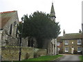
St. Bart's Chapel (2)
Grade I Listed Church within St.Bartholomew's Hospital grounds.
St.Bart's is one of the oldest established hostels for travellers and pilgrims, dating back possibly, to 1190. The Chapel is still used for various functions.
See http://www.open-sandwich.co.uk/town_history/ancient_hospitals.htm for more details on the hospital and chapel.
See also http://www.britishlistedbuildings.co.uk/en-177376-st-bartholomews-chapel-sandwich for more details about the building.
Image: © David Anstiss
Taken: 13 Feb 2011
0.02 miles
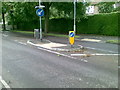
4
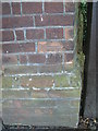
Cut Mark: Sandwich, St Bart's House, gateway
See http://www.geograph.org.uk/photo/3120706 for a wider view and http://www.bench-marks.org.uk/bm45286 for details of the mark.
Image: © Brian Westlake
Taken: 25 Jun 2012
0.03 miles
5
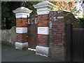
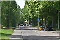
Sandwich, St Bart's House, gateway
A cut bench mark is on the nearest brickwork. See http://www.geograph.org.uk/photo/3120794 for a close-up and http://www.bench-marks.org.uk/bm45286 for details of the mark.
Image: © Brian Westlake
Taken: 25 Jun 2012
0.03 miles