IMAGES TAKEN NEAR TO
St. Margarets Street, CANTERBURY, CT1 2TH
Introduction
This page details the photographs taken nearby to St. Margarets Street, CT1 2TH by members of the Geograph project.
The Geograph project started in 2005 with the aim of publishing, organising and preserving representative images for every square kilometre of Great Britain, Ireland and the Isle of Man.

There are currently over 7.5m images from over14,400 individuals and you can help contribute to the project by visiting https://www.geograph.org.uk
Image Map
Images are licensed for reuse under creativecommons.org/licenses/by-sa/2.0
Notes
- Clicking on the map will re-center to the selected point.
- The higher the marker number, the further away the image location is from the centre of the postcode.
Image Listing (2537 Images Found)
Images are licensed for reuse under creativecommons.org/licenses/by-sa/2.0
Image
Details
Distance
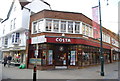
2
Canterbury: St Margaret's Street
Image: © Christopher Hilton
Taken: 26 Nov 2018
0.00 miles
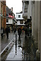
3
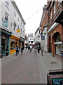
Canterbury, St Margaret's Street
Canterbury, St Margaret's Street seen from High Street.
Image: © Helmut Zozmann
Taken: 28 Jul 2011
0.01 miles
4
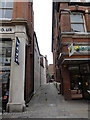
Canterbury, St Margaret's Street
Canterbury, St Margaret's Street. Unnamed alleyway connecting St Margaret's Street and Rose Lane.
Image: © Helmut Zozmann
Taken: 28 Jul 2011
0.01 miles
5
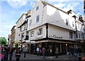
Hotel Chocolat, Parade
Grade II listed building. http://www.britishlistedbuildings.co.uk/en-440587-8-canterbury , now a chocolate shop.
Image: © N Chadwick
Taken: 14 May 2011
0.01 miles
6
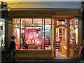
L'Occitane, St Margaret's Street
Natural beauty products shop.
Image: © Oast House Archive
Taken: 18 Dec 2011
0.01 miles
7
![Canterbury buildings [223]](https://s0.geograph.org.uk/geophotos/07/10/95/7109544_d9fd3786_120x120.jpg)
Canterbury buildings [223]
Numbers 27, 28 and 29 St Margaret's Street are a row of three, originally, houses dated 1775. Constructed of brick, numbers 27 and 29 stuccoed, number 28 painted, all under a tile roof. Numbers 28 and 29 have late 19th century shopfronts. Listed, grade II, with details at: https://historicengland.org.uk/listing/the-list/list-entry/1241920
Canterbury is a small historic city on the River Stour in Kent, some 54 miles southeast of London. Occupied since prehistoric times, it became an important Roman city. In 672, the see of Canterbury gained authority over the entire English Church. After the murder of Archbishop Thomas Becket at the cathedral in 1170, pilgrims from all parts of Christendom came to visit his shrine until the Dissolution. Today, Canterbury is a popular tourist destination and one of the most-visited cities in the United Kingdom. The city has a substantial student population, with four university campuses.
Image: © Michael Dibb
Taken: 11 Sep 2021
0.01 miles
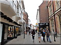
8
Canterbury, St Margaret's Street
Canterbury, St Margaret's Street, looking towards High Street. Parts of the Cathedral are visible in the distance.
Image: © Helmut Zozmann
Taken: 28 Jul 2011
0.01 miles
9
![Canterbury buildings [224]](https://s1.geograph.org.uk/geophotos/07/10/95/7109545_270a57e5_120x120.jpg)
Canterbury buildings [224]
Numbers 29A and 29B St Margaret's were built in the early 19th century as a fish market in Neoclassical style. Doric pedimented front with frieze and four Doric columns. Now used as tearooms. Listed, grade II, with details at: https://historicengland.org.uk/listing/the-list/list-entry/1242082
Canterbury is a small historic city on the River Stour in Kent, some 54 miles southeast of London. Occupied since prehistoric times, it became an important Roman city. In 672, the see of Canterbury gained authority over the entire English Church. After the murder of Archbishop Thomas Becket at the cathedral in 1170, pilgrims from all parts of Christendom came to visit his shrine until the Dissolution. Today, Canterbury is a popular tourist destination and one of the most-visited cities in the United Kingdom. The city has a substantial student population, with four university campuses.
Image: © Michael Dibb
Taken: 11 Sep 2021
0.01 miles
10
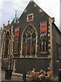
Canterbury Tales Museum
website: http://www.canterburytales.org.uk/
Image: © Paul Gillett
Taken: 30 Jul 2010
0.01 miles