IMAGES TAKEN NEAR TO
Worthgate Place, CANTERBURY, CT1 2QX
Introduction
This page details the photographs taken nearby to Worthgate Place, CT1 2QX by members of the Geograph project.
The Geograph project started in 2005 with the aim of publishing, organising and preserving representative images for every square kilometre of Great Britain, Ireland and the Isle of Man.

There are currently over 7.5m images from over14,400 individuals and you can help contribute to the project by visiting https://www.geograph.org.uk
Image Map
Images are licensed for reuse under creativecommons.org/licenses/by-sa/2.0
Notes
- Clicking on the map will re-center to the selected point.
- The higher the marker number, the further away the image location is from the centre of the postcode.
Image Listing (1005 Images Found)
Images are licensed for reuse under creativecommons.org/licenses/by-sa/2.0
Image
Details
Distance
1
![Canterbury houses [249]](https://s1.geograph.org.uk/geophotos/07/10/71/7107117_c8697a60_120x120.jpg)
Canterbury houses [249]
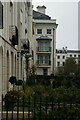
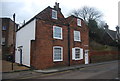
Numbers 9 and 10 Worthgate Place are a pair of early 18th century houses. Constructed of red brick under a tiled mansard roof. Listed, grade II, with details at: https://historicengland.org.uk/listing/the-list/list-entry/1258060
Canterbury is a small historic city on the River Stour in Kent, some 54 miles southeast of London. Occupied since prehistoric times, it became an important Roman city. In 672, the see of Canterbury gained authority over the entire English Church. After the murder of Archbishop Thomas Becket at the cathedral in 1170, pilgrims from all parts of Christendom came to visit his shrine until the Dissolution. Today, Canterbury is a popular tourist destination and one of the most-visited cities in the United Kingdom. The city has a substantial student population, with four university campuses.
Image: © Michael Dibb
Taken: 8 Sep 2021
0.00 miles
2
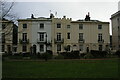
9 - 10, Worthgate Place
Grade II listed. http://www.britishlistedbuildings.co.uk/en-444202-9-and-10-worthgate-place-kent
Image: © N Chadwick
Taken: 13 Jan 2013
0.01 miles
3
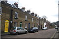
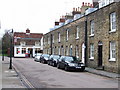
Worthgate Place
Grade II listed terrace. http://www.britishlistedbuildings.co.uk/en-444201-worthgate-place-kent
Image: © N Chadwick
Taken: 13 Jan 2013
0.01 miles
4
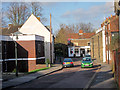
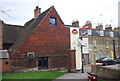
Castle Row
Shepherd Neame White Hart pub ahead.
Image: © Oast House Archive
Taken: 12 Feb 2011
0.01 miles
5
Castle Row
Shepherd Neame White Hart pub ahead.
Image: © Oast House Archive
Taken: 12 Feb 2011
0.01 miles
6
![Canterbury houses [248]](https://s3.geograph.org.uk/geophotos/07/10/71/7107115_0bbf8a9a_120x120.jpg)
Canterbury houses [248]
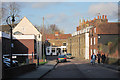
Number 1 to 8 Worthgate Place are a row of late 18th or early 19th century houses. Constructed of buff brick under a tile roof. Listed, grade II, with details at: https://historicengland.org.uk/listing/the-list/list-entry/1259753
Canterbury is a small historic city on the River Stour in Kent, some 54 miles southeast of London. Occupied since prehistoric times, it became an important Roman city. In 672, the see of Canterbury gained authority over the entire English Church. After the murder of Archbishop Thomas Becket at the cathedral in 1170, pilgrims from all parts of Christendom came to visit his shrine until the Dissolution. Today, Canterbury is a popular tourist destination and one of the most-visited cities in the United Kingdom. The city has a substantial student population, with four university campuses.
Image: © Michael Dibb
Taken: 8 Sep 2021
0.01 miles