IMAGES TAKEN NEAR TO
Castle Street, CANTERBURY, CT1 2QJ
Introduction
This page details the photographs taken nearby to Castle Street, CT1 2QJ by members of the Geograph project.
The Geograph project started in 2005 with the aim of publishing, organising and preserving representative images for every square kilometre of Great Britain, Ireland and the Isle of Man.

There are currently over 7.5m images from over14,400 individuals and you can help contribute to the project by visiting https://www.geograph.org.uk
Image Map
Images are licensed for reuse under creativecommons.org/licenses/by-sa/2.0
Notes
- Clicking on the map will re-center to the selected point.
- The higher the marker number, the further away the image location is from the centre of the postcode.
Image Listing (1563 Images Found)
Images are licensed for reuse under creativecommons.org/licenses/by-sa/2.0
Image
Details
Distance
1
![Canterbury buildings [171]](https://s0.geograph.org.uk/geophotos/07/10/23/7102328_61cf709b_120x120.jpg)
Canterbury buildings [171]
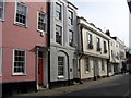
Seen here are numbers 14 to 16 Castle Street. Number 14 along with numbers 12 and 13 is part of an 18th century building refronted in the 19th century Image
Numbers 15 and 16 Castle Street are an 18th century building of painted brick under an old tile roof. Listed, grade II, with details at: https://historicengland.org.uk/listing/the-list/list-entry/1252090
Canterbury is a small historic city on the River Stour in Kent, some 54 miles southeast of London. Occupied since prehistoric times, it became an important Roman city. In 672, the see of Canterbury gained authority over the entire English Church. After the murder of Archbishop Thomas Becket at the cathedral in 1170, pilgrims from all parts of Christendom came to visit his shrine until the Dissolution. Today, Canterbury is a popular tourist destination and one of the most-visited cities in the United Kingdom. The city has a substantial student population, with four university campuses.
Image: © Michael Dibb
Taken: 8 Sep 2021
0.00 miles
3
![Canterbury buildings [172]](https://s1.geograph.org.uk/geophotos/07/10/23/7102329_36242606_120x120.jpg)
Canterbury buildings [172]
Numbers 17 and 18 Castle Street are an early 19th century building in painted brick. Listed, grade II, with details at: https://historicengland.org.uk/listing/the-list/list-entry/1085093
Canterbury is a small historic city on the River Stour in Kent, some 54 miles southeast of London. Occupied since prehistoric times, it became an important Roman city. In 672, the see of Canterbury gained authority over the entire English Church. After the murder of Archbishop Thomas Becket at the cathedral in 1170, pilgrims from all parts of Christendom came to visit his shrine until the Dissolution. Today, Canterbury is a popular tourist destination and one of the most-visited cities in the United Kingdom. The city has a substantial student population, with four university campuses.
Image: © Michael Dibb
Taken: 8 Sep 2021
0.01 miles
4
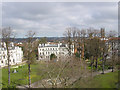
View over the park from the Dane John tower
Image: © david mills
Taken: 31 Mar 2008
0.01 miles
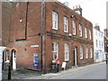
5
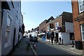
Castle Street
Hospital Lane is ahead on the right.
Image: © DS Pugh
Taken: 20 Aug 2019
0.01 miles
6
![Canterbury buildings [182]](https://s1.geograph.org.uk/geophotos/07/10/33/7103397_4447bcba_120x120.jpg)
Canterbury buildings [182]
Number 67 Castle Street is a 16th century building refronted in the 18th century. Timber framed, jettied to the side, refronted in red brick, all under an old tile roof. Listed, grade II, with details at: https://historicengland.org.uk/listing/the-list/list-entry/1336803
Canterbury is a small historic city on the River Stour in Kent, some 54 miles southeast of London. Occupied since prehistoric times, it became an important Roman city. In 672, the see of Canterbury gained authority over the entire English Church. After the murder of Archbishop Thomas Becket at the cathedral in 1170, pilgrims from all parts of Christendom came to visit his shrine until the Dissolution. Today, Canterbury is a popular tourist destination and one of the most-visited cities in the United Kingdom. The city has a substantial student population, with four university campuses.
Image: © Michael Dibb
Taken: 11 Sep 2021
0.01 miles
7
![Canterbury buildings [173]](https://s0.geograph.org.uk/geophotos/07/10/23/7102332_42305881_120x120.jpg)
Canterbury buildings [173]
Numbers 19, 20 and 21 Castle Street occupy an early 19th century building. Constructed of red brick under an old tiled roof. Listed, grade II, with details at: https://historicengland.org.uk/listing/the-list/list-entry/1085094
Canterbury is a small historic city on the River Stour in Kent, some 54 miles southeast of London. Occupied since prehistoric times, it became an important Roman city. In 672, the see of Canterbury gained authority over the entire English Church. After the murder of Archbishop Thomas Becket at the cathedral in 1170, pilgrims from all parts of Christendom came to visit his shrine until the Dissolution. Today, Canterbury is a popular tourist destination and one of the most-visited cities in the United Kingdom. The city has a substantial student population, with four university campuses.
Image: © Michael Dibb
Taken: 8 Sep 2021
0.01 miles
8
![Canterbury houses [198]](https://s3.geograph.org.uk/geophotos/07/10/23/7102327_9ece8874_120x120.jpg)
Canterbury houses [198]
Numbers 12 and 13 Castle Street, seen here, and number 14 Castle Street Image, occupy an 18th century building refronted in the 19th century. Constructed of painted brick under a tile roof. Listed, grade II, with details at: https://historicengland.org.uk/listing/the-list/list-entry/1085092
Canterbury is a small historic city on the River Stour in Kent, some 54 miles southeast of London. Occupied since prehistoric times, it became an important Roman city. In 672, the see of Canterbury gained authority over the entire English Church. After the murder of Archbishop Thomas Becket at the cathedral in 1170, pilgrims from all parts of Christendom came to visit his shrine until the Dissolution. Today, Canterbury is a popular tourist destination and one of the most-visited cities in the United Kingdom. The city has a substantial student population, with four university campuses.
Image: © Michael Dibb
Taken: 8 Sep 2021
0.01 miles
9
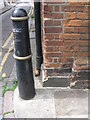
Cut bench mark on 68 Castle Street
See http://www.geograph.org.uk/photo/3072015 for a wider view and http://www.bench-marks.org.uk/bm44569 for details of the mark.
Image: © Brian Westlake
Taken: 23 Jun 2012
0.02 miles
10
Gallery, 68 Castle Street
The building carries a cut bench mark on the nearest angle. See http://www.geograph.org.uk/photo/3072007 for a close-up.
Image: © Brian Westlake
Taken: 23 Jun 2012
0.02 miles