IMAGES TAKEN NEAR TO
Hospital Lane, CANTERBURY, CT1 2PE
Introduction
This page details the photographs taken nearby to Hospital Lane, CT1 2PE by members of the Geograph project.
The Geograph project started in 2005 with the aim of publishing, organising and preserving representative images for every square kilometre of Great Britain, Ireland and the Isle of Man.

There are currently over 7.5m images from over14,400 individuals and you can help contribute to the project by visiting https://www.geograph.org.uk
Image Map (Loading...)


Getting Data...Please wait
Leaflet Map data © OpenStreetMap
Images are licensed for reuse under creativecommons.org/licenses/by-sa/2.0
Notes
- Clicking on the map will re-center to the selected point.
- The higher the marker number, the further away the image location is from the centre of the postcode.
Image Listing (1683 Images Found)
Images are licensed for reuse under creativecommons.org/licenses/by-sa/2.0
Image
Details
Distance
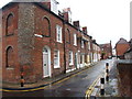
3
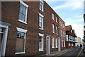
Maynard and Cotton's Hospital
Grade II listed. http://www.britishlistedbuildings.co.uk/en-439375-maynard-and-cotton-s-hospital-1-2-5-and-
Image: © N Chadwick
Taken: 14 May 2011
0.01 miles
4
Maynards & Cotton's Hospital
Grade II listed. http://www.britishlistedbuildings.co.uk/en-439375-maynard-and-cotton-s-hospital-kent
Image: © N Chadwick
Taken: 22 Aug 2015
0.01 miles
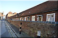
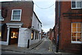
5

Hookers Almshouses
Grade II listed. https://www.britishlistedbuildings.co.uk/101240821-maynard-and-cottons-hospital-canterbury
Image: © N Chadwick
Taken: 13 Feb 2018
0.01 miles
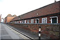
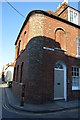
7
![Canterbury houses [216]](https://s3.geograph.org.uk/geophotos/07/10/56/7105607_d93b95e2_120x120.jpg)
Canterbury houses [216]
Numbers 1, 2, 5 and 6 Hospital Lane were originally part of Maynard and Cotton's Hospital. Founded in 1317 for the support of three old men and one old woman. There were alterations in 1617 and 1708. The present building is mostly 19th century of brick under a tile roof with a Dutch gable. Listed, grade II, with details at: https://historicengland.org.uk/listing/the-list/list-entry/1240821
Canterbury is a small historic city on the River Stour in Kent, some 54 miles southeast of London. Occupied since prehistoric times, it became an important Roman city. In 672, the see of Canterbury gained authority over the entire English Church. After the murder of Archbishop Thomas Becket at the cathedral in 1170, pilgrims from all parts of Christendom came to visit his shrine until the Dissolution. Today, Canterbury is a popular tourist destination and one of the most-visited cities in the United Kingdom. The city has a substantial student population, with four university campuses.
Image: © Michael Dibb
Taken: 11 Sep 2021
0.01 miles
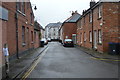
10
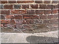
Cut bench mark in Stour Street
The mark is on the end of 21 Hospital Lane. See http://www.geograph.org.uk/photo/3072083 for a wider view and http://www.bench-marks.org.uk/bm44575 for details of the mark.
Image: © Brian Westlake
Taken: 23 Jun 2012
0.02 miles