IMAGES TAKEN NEAR TO
Clearwater Mews, CANTERBURY, CT1 2LZ
Introduction
This page details the photographs taken nearby to Clearwater Mews, CT1 2LZ by members of the Geograph project.
The Geograph project started in 2005 with the aim of publishing, organising and preserving representative images for every square kilometre of Great Britain, Ireland and the Isle of Man.

There are currently over 7.5m images from over14,400 individuals and you can help contribute to the project by visiting https://www.geograph.org.uk
Image Map
Images are licensed for reuse under creativecommons.org/licenses/by-sa/2.0
Notes
- Clicking on the map will re-center to the selected point.
- The higher the marker number, the further away the image location is from the centre of the postcode.
Image Listing (1460 Images Found)
Images are licensed for reuse under creativecommons.org/licenses/by-sa/2.0
Image
Details
Distance
1
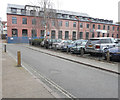
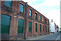
Conversion of former St Mildred's Tannery, Stour Street
Planning permission was granted by Canterbury City Council under application number CA//15/00183 for the “erection of new buildings and conversion of existing buildings to residential comprising 2 and 3 bedroom town houses, apartments and duplex apartments (24 units in total)”.
This image shows the Image in April 2018.
Image: © John Baker
Taken: 16 Mar 2019
0.01 miles
2
![Canterbury houses [212]](https://s0.geograph.org.uk/geophotos/07/10/55/7105592_9265d17c_120x120.jpg)
Canterbury houses [212]
Number 47 Stour Street was built in the early 19thcentury. Constructed of brick, the front painted. Listed, grade II, with details at: https://historicengland.org.uk/listing/the-list/list-entry/1242652
Canterbury is a small historic city on the River Stour in Kent, some 54 miles southeast of London. Occupied since prehistoric times, it became an important Roman city. In 672, the see of Canterbury gained authority over the entire English Church. After the murder of Archbishop Thomas Becket at the cathedral in 1170, pilgrims from all parts of Christendom came to visit his shrine until the Dissolution. Today, Canterbury is a popular tourist destination and one of the most-visited cities in the United Kingdom. The city has a substantial student population, with four university campuses.
Image: © Michael Dibb
Taken: 11 Sep 2021
0.01 miles
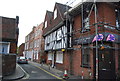
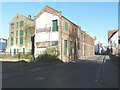
3
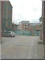
Clearwater Mews, off Stour Street
This is a development of 6 houses, 3 duplexes and 1 penthouse being built by TG Designer Homes http://tgdesignerhomes.com/city/ In my photograph of Image, the entrance to the mews is the gap between St Mildred’s Tannery and the houses to its right.
Image: © John Baker
Taken: 24 Aug 2014
0.01 miles
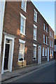
4
Clearwater Mews, off Stour Street
Compared with Image, photographed in August 2014, the building in the foreground now almost obscures that behind it.
Image: © John Baker
Taken: 4 Feb 2015
0.01 miles
8
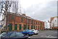
44 - 46, Stour St
Grade II listed. http://www.britishlistedbuildings.co.uk/en-443440-44-46-stour-street-kent
Image: © N Chadwick
Taken: 22 Aug 2015
0.02 miles
9
Conversion of former St Mildred's Tannery, Stour Street
Planning permission was granted by Canterbury City Council under application number CA//15/00183 for the “erection of new buildings and conversion of existing buildings to residential comprising 2 and 3 bedroom town houses, apartments and duplex apartments (24 units in total)”.
This image shows the Image in November 2016.
Image: © John Baker
Taken: 29 Apr 2018
0.02 miles
10
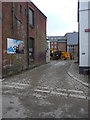
All that remains of St Mildred's Tannery, Stour Street
The rest has been demolished to make way for the development known as The Old Tannery which extends to Rheims Way. Planning permission has been granted by Canterbury City Council under application number CA//04/00012 for the “demolition of buildings in connection with redevelopment to provide 444 houses and flats, 283 off-street car parking spaces, 64 bed hotel, 4 retail units (A1), 1 wine bar/restaurant (A3), 3 live/work units, 2 pedestrian bridges, public park and riverside walk”. The site has been occupied by the tannery since the 18th century.
Image: © John Baker
Taken: 2 Dec 2012
0.02 miles