IMAGES TAKEN NEAR TO
Lower Bridge Street, CANTERBURY, CT1 2LG
Introduction
This page details the photographs taken nearby to Lower Bridge Street, CT1 2LG by members of the Geograph project.
The Geograph project started in 2005 with the aim of publishing, organising and preserving representative images for every square kilometre of Great Britain, Ireland and the Isle of Man.

There are currently over 7.5m images from over14,400 individuals and you can help contribute to the project by visiting https://www.geograph.org.uk
Image Map
Images are licensed for reuse under creativecommons.org/licenses/by-sa/2.0
Notes
- Clicking on the map will re-center to the selected point.
- The higher the marker number, the further away the image location is from the centre of the postcode.
Image Listing (1654 Images Found)
Images are licensed for reuse under creativecommons.org/licenses/by-sa/2.0
Image
Details
Distance
1
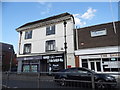
Shops on Lower Bridge Street, Canterbury
Image: © David Howard
Taken: 31 Jul 2016
0.00 miles
2
![Canterbury buildings [74]](https://s2.geograph.org.uk/geophotos/07/09/13/7091318_83be703d_120x120.jpg)
Canterbury buildings [74]
Numbers 16, 17 and 18 Church Street, along with number 24 Lower Bridge Street, form a tall corner building dated 1714. Constructed of painted brick under a hipped tile roof. Listed, grade II, with details at: https://historicengland.org.uk/listing/the-list/list-entry/1085042
Canterbury is a small historic city on the River Stour in Kent, some 54 miles southeast of London. Occupied since prehistoric times, it became an important Roman city. In 672, the see of Canterbury gained authority over the entire English Church. After the murder of Archbishop Thomas Becket at the cathedral in 1170, pilgrims from all parts of Christendom came to visit his shrine until the Dissolution. Today, Canterbury is a popular tourist destination and one of the most-visited cities in the United Kingdom. The city has a substantial student population, with four university campuses.
Image: © Michael Dibb
Taken: 7 Sep 2021
0.02 miles
3
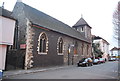
Church of St Paul without the Walls
Grade B listed. http://www.britishlistedbuildings.co.uk/en-170579-church-of-st-paul-without-the-walls-cant
Image: © N Chadwick
Taken: 7 Jan 2012
0.02 miles
4
![Canterbury buildings [210]](https://s1.geograph.org.uk/geophotos/07/10/79/7107965_186d5a5f_120x120.jpg)
Canterbury buildings [210]
Number 24 Lower Bridge Street is a 16th or 17th century building, refronted in the 18th century. Timber framed, refronted in painted brick, the ground floor underbuilt, all under a hipped tile roof. Listed, grade II, with details at: https://historicengland.org.uk/listing/the-list/list-entry/1334341
Image: © Michael Dibb
Taken: 9 Sep 2021
0.02 miles
7
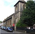
Church of St Paul without the walls
Grade B listed. http://www.britishlistedbuildings.co.uk/en-170579-church-of-st-paul-without-the-walls-cant
Image: © N Chadwick
Taken: 14 May 2011
0.02 miles
8

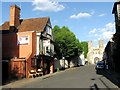
Church St
Image: © N Chadwick
Taken: 7 Jan 2012
0.02 miles
10
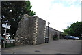
![Canterbury buildings [72]](https://s1.geograph.org.uk/geophotos/07/09/13/7091313_9621805b_120x120.jpg)
Canterbury buildings [72]
Now a restaurant, number 4 Church Street, is the former Duke's Head Inn. Built in the 16th century, greatly restored, timber framed, jettied gable end to the street, all under a tile roof. Listed, grade II, with details at: https://historicengland.org.uk/listing/the-list/list-entry/1336813
Canterbury is a small historic city on the River Stour in Kent, some 54 miles southeast of London. Occupied since prehistoric times, it became an important Roman city. In 672, the see of Canterbury gained authority over the entire English Church. After the murder of Archbishop Thomas Becket at the cathedral in 1170, pilgrims from all parts of Christendom came to visit his shrine until the Dissolution. Today, Canterbury is a popular tourist destination and one of the most-visited cities in the United Kingdom. The city has a substantial student population, with four university campuses.
Image: © Michael Dibb
Taken: 7 Sep 2021
0.03 miles