IMAGES TAKEN NEAR TO
St. Andrews Close, CANTERBURY, CT1 2LF
Introduction
This page details the photographs taken nearby to St. Andrews Close, CT1 2LF by members of the Geograph project.
The Geograph project started in 2005 with the aim of publishing, organising and preserving representative images for every square kilometre of Great Britain, Ireland and the Isle of Man.

There are currently over 7.5m images from over14,400 individuals and you can help contribute to the project by visiting https://www.geograph.org.uk
Image Map
Images are licensed for reuse under creativecommons.org/licenses/by-sa/2.0
Notes
- Clicking on the map will re-center to the selected point.
- The higher the marker number, the further away the image location is from the centre of the postcode.
Image Listing (647 Images Found)
Images are licensed for reuse under creativecommons.org/licenses/by-sa/2.0
Image
Details
Distance
1
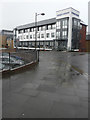
Logan House, St Andrews Close
This image shows the Image; the building now houses offices.
Image: © John Baker
Taken: 4 Feb 2018
0.03 miles
2

Ongoing construction, Logan House, St Andrews Close
Planning permission has been granted by Canterbury City Council under application number CA//14/00196 for the “erection of office building comprising 3 storey extension above existing ground floor plus single storey extension to south west corner; construction of upper ground floor pedestrian access from back of footpath”. The location was described as Block A, St Andrews Close.
Image: © John Baker
Taken: 10 Jul 2016
0.04 miles
3
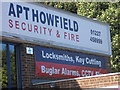
Buglar Alarms
Spelling error on company building. Also visible on Google streetview.
Image: © Arjen Bax
Taken: 15 Aug 2009
0.06 miles
4
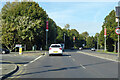
A2050 Rheims Way, Canterbury
A more ring-like bit of a Canterbury ring road system. Some maps label this stretch as the A290.
Image: © Robin Webster
Taken: 13 Oct 2018
0.06 miles
5

Wincheap, looking towards the railway bridge
Image: © david mills
Taken: 31 Mar 2008
0.06 miles
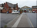
6
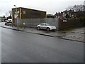
1, Simmonds Road
These trade counter premises, with yard, are to let for £29,000 per annum, according to Caxtons’ (chartered surveyors) website http://www.caxtons.com/
Image: © John Baker
Taken: 4 Jan 2016
0.06 miles
7
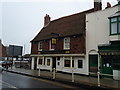
The Maidens Head public house, Wincheap, Canterbury
Image: © Stacey Harris
Taken: 28 Dec 2010
0.07 miles
9
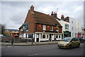
The Maiden's Head Inn
Grade II listed. http://www.britishlistedbuildings.co.uk/en-444115-the-maiden-s-head-inn-kent
Image: © N Chadwick
Taken: 13 Jan 2013
0.07 miles
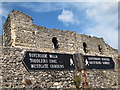
10
The rear of the Maiden's Head, 28, Wincheap
Planning permission has been granted by Canterbury City Council under application number CA//15/01030 for the “conversion of roof space and part-first floor to guest rooms and en-suites; works to include construction of dormer windows, staircase and installation of roof-lights along with internal and external alterations”. The external alterations will be evident from this angle in Simmonds Road.
It is a grade II listed timber-framed building, that dates from the 15th century and was refaced in the 18th century http://www.britishlistedbuildings.co.uk/en-444115-the-maiden-s-head-inn-kent#.Vpf3OsLcvcc
Image: © John Baker
Taken: 4 Jan 2016
0.07 miles