IMAGES TAKEN NEAR TO
Guildhall Street, CANTERBURY, CT1 2JQ
Introduction
This page details the photographs taken nearby to Guildhall Street, CT1 2JQ by members of the Geograph project.
The Geograph project started in 2005 with the aim of publishing, organising and preserving representative images for every square kilometre of Great Britain, Ireland and the Isle of Man.

There are currently over 7.5m images from over14,400 individuals and you can help contribute to the project by visiting https://www.geograph.org.uk
Image Map
Images are licensed for reuse under creativecommons.org/licenses/by-sa/2.0
Notes
- Clicking on the map will re-center to the selected point.
- The higher the marker number, the further away the image location is from the centre of the postcode.
Image Listing (2709 Images Found)
Images are licensed for reuse under creativecommons.org/licenses/by-sa/2.0
Image
Details
Distance
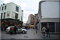
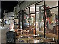
1
Looking northeast along Guildhall Street
The street was only open to pedestrians as contractors, working on behalf of Southern Water, had dug a hole in the road surface, which explains why their large red van is parked just ahead.
Image: © John Baker
Taken: 4 Feb 2015
0.00 miles
2
![Canterbury buildings [321]](https://s3.geograph.org.uk/geophotos/07/11/46/7114607_17618dd3_120x120.jpg)
Canterbury buildings [321]
Numbers 1, 1A and 2 Guildhall Street were built in the late 18th or early 19th century. Constructed of buff brick under a tile roof. Listed, grade II, with details at: https://historicengland.org.uk/listing/the-list/list-entry/1240639
Canterbury is a small historic city on the River Stour in Kent, some 54 miles southeast of London. Occupied since prehistoric times, it became an important Roman city. In 672, the see of Canterbury gained authority over the entire English Church. After the murder of Archbishop Thomas Becket at the cathedral in 1170, pilgrims from all parts of Christendom came to visit his shrine until the Dissolution. Today, Canterbury is a popular tourist destination and one of the most-visited cities in the United Kingdom. The city has a substantial student population, with four university campuses.
Image: © Michael Dibb
Taken: 12 Sep 2021
0.00 miles
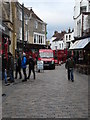
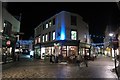
5
La Trappiste
Café on Guildhall Street.
Image: © Oast House Archive
Taken: 18 Dec 2011
0.01 miles
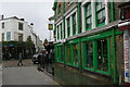
6
La Trappiste
Café at the corner of Sun Street and Guildhall Street.
Image: © Oast House Archive
Taken: 18 Dec 2011
0.01 miles
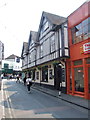
8
Orange Street & Palace Street junction
At cross roads with Guildhall Street and Sun Street.
Image: © Oast House Archive
Taken: 20 Apr 2012
0.01 miles
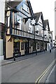
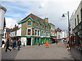
9
![Canterbury buildings [304]](https://s2.geograph.org.uk/geophotos/07/11/34/7113494_7dda1123_120x120.jpg)
Canterbury buildings [304]
The Seven Stars Hotel, number 1 Orange Street is a 16th or 17th century building refronted in, probably, the 19th century. Timber framed, jettied to the street. The ground floor is stuccoed brick, the upper floors are plastered with applied timber framing, all under a tile roof. Listed, grade II, with details at: https://historicengland.org.uk/listing/the-list/list-entry/1260531
Canterbury is a small historic city on the River Stour in Kent, some 54 miles southeast of London. Occupied since prehistoric times, it became an important Roman city. In 672, the see of Canterbury gained authority over the entire English Church. After the murder of Archbishop Thomas Becket at the cathedral in 1170, pilgrims from all parts of Christendom came to visit his shrine until the Dissolution. Today, Canterbury is a popular tourist destination and one of the most-visited cities in the United Kingdom. The city has a substantial student population, with four university campuses.
Image: © Michael Dibb
Taken: 10 Sep 2021
0.01 miles