IMAGES TAKEN NEAR TO
St. Peters Place, CANTERBURY, CT1 2DB
Introduction
This page details the photographs taken nearby to St. Peters Place, CT1 2DB by members of the Geograph project.
The Geograph project started in 2005 with the aim of publishing, organising and preserving representative images for every square kilometre of Great Britain, Ireland and the Isle of Man.

There are currently over 7.5m images from over14,400 individuals and you can help contribute to the project by visiting https://www.geograph.org.uk
Image Map
Images are licensed for reuse under creativecommons.org/licenses/by-sa/2.0
Notes
- Clicking on the map will re-center to the selected point.
- The higher the marker number, the further away the image location is from the centre of the postcode.
Image Listing (1588 Images Found)
Images are licensed for reuse under creativecommons.org/licenses/by-sa/2.0
Image
Details
Distance
1
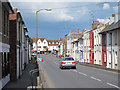
St Peter's Place
Colourful terraced houses leading towards the city gate.
Image: © Oast House Archive
Taken: 20 Apr 2012
0.01 miles
3
![Canterbury houses [88]](https://s1.geograph.org.uk/geophotos/07/09/05/7090561_68aac010_120x120.jpg)
Canterbury houses [88]
Numbers 32 to 68 St Pater's Place is a mid 19th century non-uniform terrace development. Constructed of buff brick, some stuccoed, some painted, under slate roofs. Listed, grade II, with details at: https://historicengland.org.uk/listing/the-list/list-entry/1242337
Canterbury is a small historic city on the River Stour in Kent, some 54 miles southeast of London. Occupied since prehistoric times, it became an important Roman city. In 672, the see of Canterbury gained authority over the entire English Church. After the murder of Archbishop Thomas Becket at the cathedral in 1170, pilgrims from all parts of Christendom came to visit his shrine until the Dissolution. Today, Canterbury is a popular tourist destination and one of the most-visited cities in the United Kingdom. The city has a substantial student population, with four university campuses.
Image: © Michael Dibb
Taken: 6 Sep 2021
0.01 miles
5
![Canterbury houses [87]](https://s3.geograph.org.uk/geophotos/07/09/05/7090559_6b27acd8_120x120.jpg)
Canterbury houses [87]
Numbers 1 to 25 St Peter's Place are a mid 19th century development of mostly semi-detached cottages. Constructed of buff brick, some stuccoed, some painted, under slate roofs. Listed, grade II, with details at: https://historicengland.org.uk/listing/the-list/list-entry/1242336
Canterbury is a small historic city on the River Stour in Kent, some 54 miles southeast of London. Occupied since prehistoric times, it became an important Roman city. In 672, the see of Canterbury gained authority over the entire English Church. After the murder of Archbishop Thomas Becket at the cathedral in 1170, pilgrims from all parts of Christendom came to visit his shrine until the Dissolution. Today, Canterbury is a popular tourist destination and one of the most-visited cities in the United Kingdom. The city has a substantial student population, with four university campuses.
Image: © Michael Dibb
Taken: 6 Sep 2021
0.02 miles
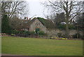
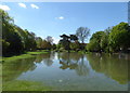
6
Westgate Gardens, Canterbury
Looking towards the Tower House, a late 19th century Grade II listed building, https://britishlistedbuildings.co.uk/101241781-tower-house-canterbury#.W6ts3vZFw5s in the background.
Image: © G Laird
Taken: 16 Sep 2018
0.03 miles
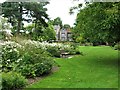
7

Spanish bluebells, Canterbury
In Westgate Gardens.
Image: © pam fray
Taken: 1 May 2018
0.03 miles
8
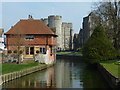
The Great Stour looking towards Westgate Towers
Image: © pam fray
Taken: 25 Mar 2011
0.03 miles
9
Flooding, Great Stour river, Canterbury
Westgate Gardens.
Image: © pam fray
Taken: 1 May 2018
0.03 miles
10
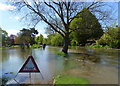
Flooding, Great Stour river, Canterbury
This is normally a footpath through Westgate Gardens.
Image: © pam fray
Taken: 1 May 2018
0.04 miles