IMAGES TAKEN NEAR TO
Newington Road, RAMSGATE, CT12 6PY
Introduction
This page details the photographs taken nearby to Newington Road, CT12 6PY by members of the Geograph project.
The Geograph project started in 2005 with the aim of publishing, organising and preserving representative images for every square kilometre of Great Britain, Ireland and the Isle of Man.

There are currently over 7.5m images from over14,400 individuals and you can help contribute to the project by visiting https://www.geograph.org.uk
Image Map (15 Images)


Getting Data...Please wait
Leaflet Map data © OpenStreetMap
Images are licensed for reuse under creativecommons.org/licenses/by-sa/2.0
Notes
- Clicking on the map will re-center to the selected point.
- The higher the marker number, the further away the image location is from the centre of the postcode.
Image Listing (15 Images Found)
Images are licensed for reuse under creativecommons.org/licenses/by-sa/2.0
Image
Details
Distance
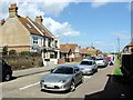
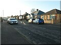
2
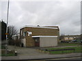
Project 15 Alternative Curriculum School
School set up in a former library building on the junction of Chichester Road (on the right) and Newington Road (in front).
Image: © David Anstiss
Taken: 6 Feb 2011
0.05 miles
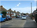
7
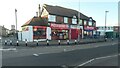
Somewhere to eat on Newington Road
A cafe and two takeaways. When built [between 1931 and 1936] this would have been a parade of retail shops.
Image: © Christine Johnstone
Taken: 17 Feb 2022
0.20 miles
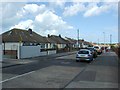
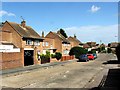
9
Bungalows on Kings Avenue, Newington
A suburb of Ramsgate. The road was laid out between 1896 and 1905, and the bungalows built between 1931 and 1936.
Image: © Christine Johnstone
Taken: 17 Feb 2022
0.21 miles
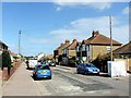
10
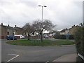
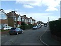
Roundabout on Melbourne Avenue
Melbourne Avenue winds through Newington from Whitehall towards the B2050 Manston Road. Bush Avenue heads left towards Newington Road.
St.John's Avenue heads right though The Centre towards the A256 Haine Road.
Image: © David Anstiss
Taken: 6 Feb 2011
0.22 miles