IMAGES TAKEN NEAR TO
Quetta Road, RAMSGATE, CT12 6NG
Introduction
This page details the photographs taken nearby to Quetta Road, CT12 6NG by members of the Geograph project.
The Geograph project started in 2005 with the aim of publishing, organising and preserving representative images for every square kilometre of Great Britain, Ireland and the Isle of Man.

There are currently over 7.5m images from over14,400 individuals and you can help contribute to the project by visiting https://www.geograph.org.uk
Image Map
Images are licensed for reuse under creativecommons.org/licenses/by-sa/2.0
Notes
- Clicking on the map will re-center to the selected point.
- The higher the marker number, the further away the image location is from the centre of the postcode.
Image Listing (20 Images Found)
Images are licensed for reuse under creativecommons.org/licenses/by-sa/2.0
Image
Details
Distance
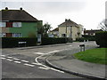
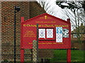
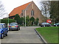
2
Newington Free Church
On the junction of Quetta Road (on the left) and St.John's Avenue (in front).
Image: © David Anstiss
Taken: 6 Feb 2011
0.06 miles
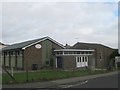
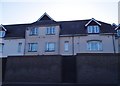
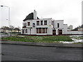
4
New Offices off Haine Road
Beside Stirling Way.
Image: © Oast House Archive
Taken: 21 Sep 2010
0.09 miles
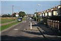
8
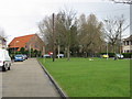
The northern end of Princess Margaret Avenue
The church is St Christophers, Newington
Image: © Nick Smith
Taken: 22 Mar 2008
0.21 miles
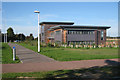
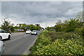
10
The Flowing Bowl pub for sale
It was open for business in March 2008 http://www.geograph.org.uk/photo/734087 but looked closed up and for sale in January 2010.
Image: © Nick Smith
Taken: 12 Jan 2010
0.21 miles