IMAGES TAKEN NEAR TO
Wentworth Drive, RAMSGATE, CT12 6JL
Introduction
This page details the photographs taken nearby to Wentworth Drive, CT12 6JL by members of the Geograph project.
The Geograph project started in 2005 with the aim of publishing, organising and preserving representative images for every square kilometre of Great Britain, Ireland and the Isle of Man.

There are currently over 7.5m images from over14,400 individuals and you can help contribute to the project by visiting https://www.geograph.org.uk
Image Map
Images are licensed for reuse under creativecommons.org/licenses/by-sa/2.0
Notes
- Clicking on the map will re-center to the selected point.
- The higher the marker number, the further away the image location is from the centre of the postcode.
Image Listing (35 Images Found)
Images are licensed for reuse under creativecommons.org/licenses/by-sa/2.0
Image
Details
Distance
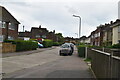
2
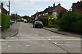
Princess Margaret Avenue, Newington
The houses are on Keith Avenue a turning off Princess Margaret Avenue.
Image: © Nick Smith
Taken: 12 Jan 2010
0.07 miles

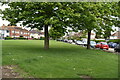
4
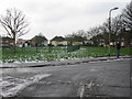
Grassed area near Keith Avenue, Newington
Image: © Nick Smith
Taken: 12 Jan 2010
0.07 miles
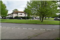
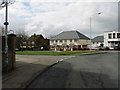
8
The Flowing Bowl Public House under demolition
This pub on the Centre of Newington, was closed in January 2010.
See Image
Now it is being demolished.
Image: © David Anstiss
Taken: 6 Feb 2011
0.10 miles
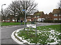
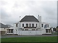
9
Princess Margaret Avenue leading from roundabout
Image: © Nick Smith
Taken: 22 Mar 2008
0.10 miles