IMAGES TAKEN NEAR TO
Beaufort Avenue, RAMSGATE, CT12 6ES
Introduction
This page details the photographs taken nearby to Beaufort Avenue, CT12 6ES by members of the Geograph project.
The Geograph project started in 2005 with the aim of publishing, organising and preserving representative images for every square kilometre of Great Britain, Ireland and the Isle of Man.

There are currently over 7.5m images from over14,400 individuals and you can help contribute to the project by visiting https://www.geograph.org.uk
Image Map
Images are licensed for reuse under creativecommons.org/licenses/by-sa/2.0
Notes
- Clicking on the map will re-center to the selected point.
- The higher the marker number, the further away the image location is from the centre of the postcode.
Image Listing (45 Images Found)
Images are licensed for reuse under creativecommons.org/licenses/by-sa/2.0
Image
Details
Distance
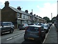
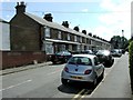
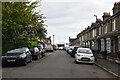
2
Beaufort Avenue, Newington, Ramsgate
This road was built after 1950.
Image: © Christine Johnstone
Taken: 17 Feb 2022
0.02 miles
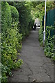
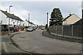
6
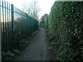
High fences and hedges on Newington footpath
This public footpath is shown on the large scale OS map from the 1870s. Then it ran through countryside to and from St Lawrence's Church.
Image: © Christine Johnstone
Taken: 17 Feb 2022
0.06 miles
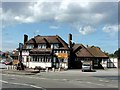
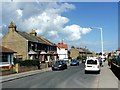
8
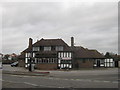
The Windmill Public House, Ramsgate
On the junction of the B2014 Newington Road (on the left) and Whitehall Road (on the right).
Image: © David Anstiss
Taken: 6 Feb 2011
0.08 miles