IMAGES TAKEN NEAR TO
Coleman Crescent, RAMSGATE, CT12 6AE
Introduction
This page details the photographs taken nearby to Coleman Crescent, CT12 6AE by members of the Geograph project.
The Geograph project started in 2005 with the aim of publishing, organising and preserving representative images for every square kilometre of Great Britain, Ireland and the Isle of Man.

There are currently over 7.5m images from over14,400 individuals and you can help contribute to the project by visiting https://www.geograph.org.uk
Image Map
Images are licensed for reuse under creativecommons.org/licenses/by-sa/2.0
Notes
- Clicking on the map will re-center to the selected point.
- The higher the marker number, the further away the image location is from the centre of the postcode.
Image Listing (15 Images Found)
Images are licensed for reuse under creativecommons.org/licenses/by-sa/2.0
Image
Details
Distance
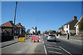
1
Stewart's Caf?, Ramsgate
On the A254 Margate Road.
Note the amusing sign outside - "Eat at Stewart's Café or We'll both Go Hungry!"
Image: © David Anstiss
Taken: 6 Feb 2011
0.05 miles
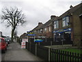
3
Summerhill Surgery
On the A254 Margate Road.
Image: © David Anstiss
Taken: 6 Feb 2011
0.13 miles
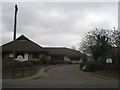
4

Converted Synagogue
This was Thanet and District Reform Synagogue on the A254 Margate Road.
Now converted into a private home.
Image: © David Anstiss
Taken: 6 Feb 2011
0.13 miles
8
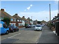
Ramsgate: Whitehall
Nixon Avenue goes down the hill to the left, Bradley Road is to the right.
Image: © Nigel Cox
Taken: 7 Jun 2007
0.18 miles
9

St. Mark's Anglican Parish Church
On the junction of the A254 Margate Road (on the left) and Pysons Road (in front).
Image: © David Anstiss
Taken: 6 Feb 2011
0.18 miles