IMAGES TAKEN NEAR TO
Cliffsend Grove, RAMSGATE, CT12 5JT
Introduction
This page details the photographs taken nearby to Cliffsend Grove, CT12 5JT by members of the Geograph project.
The Geograph project started in 2005 with the aim of publishing, organising and preserving representative images for every square kilometre of Great Britain, Ireland and the Isle of Man.

There are currently over 7.5m images from over14,400 individuals and you can help contribute to the project by visiting https://www.geograph.org.uk
Image Map
Images are licensed for reuse under creativecommons.org/licenses/by-sa/2.0
Notes
- Clicking on the map will re-center to the selected point.
- The higher the marker number, the further away the image location is from the centre of the postcode.
Image Listing (131 Images Found)
Images are licensed for reuse under creativecommons.org/licenses/by-sa/2.0
Image
Details
Distance
1
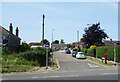
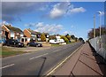
Cliffs End Grove
Like much of the coastal development, this is mid 20th century suburban in style.
Image: © Des Blenkinsopp
Taken: 15 Jun 2021
0.02 miles
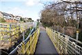
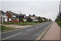
5
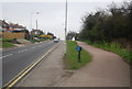
National Cycle Route 1 / Thanet Coastal Path / Sandwich Rd
Image: © N Chadwick
Taken: 5 Apr 2012
0.05 miles
7
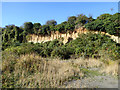
Crumbling cliff, Cliffsend
At the back of the former hovercraft port. The wilderness of the old port area seems wonderful for wildlife.
Image: © Robin Webster
Taken: 27 Oct 2017
0.06 miles
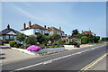
8
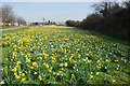
Spring arrives a little early in Cliffsend
Image: © david mills
Taken: 25 Feb 2008
0.06 miles
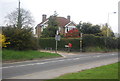
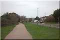
10
Sandwich Rd
The Thanet Coastal Path follows the road.
Image: © N Chadwick
Taken: 5 Apr 2012
0.08 miles