IMAGES TAKEN NEAR TO
Foads Lane, RAMSGATE, CT12 5JP
Introduction
This page details the photographs taken nearby to Foads Lane, CT12 5JP by members of the Geograph project.
The Geograph project started in 2005 with the aim of publishing, organising and preserving representative images for every square kilometre of Great Britain, Ireland and the Isle of Man.

There are currently over 7.5m images from over14,400 individuals and you can help contribute to the project by visiting https://www.geograph.org.uk
Image Map
Images are licensed for reuse under creativecommons.org/licenses/by-sa/2.0
Notes
- Clicking on the map will re-center to the selected point.
- The higher the marker number, the further away the image location is from the centre of the postcode.
Image Listing (68 Images Found)
Images are licensed for reuse under creativecommons.org/licenses/by-sa/2.0
Image
Details
Distance
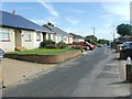
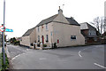
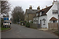
3
Foads Lane, Cliffsend, Kent
Ash Court is the road on the left of the photo.
Image: © david mills
Taken: 25 Feb 2008
0.04 miles

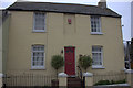
6
The Old Post Office, Cliffsend
Now a private house.
Image: © david mills
Taken: 30 Mar 2008
0.07 miles
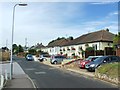
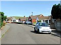
10
Foads Lane, Cottington Road junction. Cliffs End
Image: © Robert Eva
Taken: 5 Jan 2019
0.08 miles