IMAGES TAKEN NEAR TO
Mount Green Avenue, RAMSGATE, CT12 5JF
Introduction
This page details the photographs taken nearby to Mount Green Avenue, CT12 5JF by members of the Geograph project.
The Geograph project started in 2005 with the aim of publishing, organising and preserving representative images for every square kilometre of Great Britain, Ireland and the Isle of Man.

There are currently over 7.5m images from over14,400 individuals and you can help contribute to the project by visiting https://www.geograph.org.uk
Image Map
Images are licensed for reuse under creativecommons.org/licenses/by-sa/2.0
Notes
- Clicking on the map will re-center to the selected point.
- The higher the marker number, the further away the image location is from the centre of the postcode.
Image Listing (128 Images Found)
Images are licensed for reuse under creativecommons.org/licenses/by-sa/2.0
Image
Details
Distance
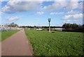
2
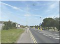
Sandwich Road, Cliffs End
With Mount Green Avenue entering from the left
Image: © John Baker
Taken: 5 Sep 2012
0.07 miles
4
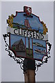
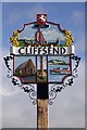
Cliffs End sign
The Cliffs End village sign includes an image of St Augustine's Cross, the 'Hugin', a Viking longship and a hovercraft. Pegwell Bay below the village used to be a hovercraft port.
Image: © Philip Halling
Taken: 16 Sep 2012
0.08 miles
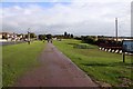
9
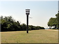
Cliffsend, Cliffsend Point, Beacon
Cliffsend, Cliffsend Point, Beacon near Viking Longboat 'Hugin'
Image: © Helmut Zozmann
Taken: 1 Aug 2011
0.09 miles