IMAGES TAKEN NEAR TO
Bakers Field, RAMSGATE, CT12 5GH
Introduction
This page details the photographs taken nearby to Bakers Field, CT12 5GH by members of the Geograph project.
The Geograph project started in 2005 with the aim of publishing, organising and preserving representative images for every square kilometre of Great Britain, Ireland and the Isle of Man.

There are currently over 7.5m images from over14,400 individuals and you can help contribute to the project by visiting https://www.geograph.org.uk
Image Map
Images are licensed for reuse under creativecommons.org/licenses/by-sa/2.0
Notes
- Clicking on the map will re-center to the selected point.
- The higher the marker number, the further away the image location is from the centre of the postcode.
Image Listing (53 Images Found)
Images are licensed for reuse under creativecommons.org/licenses/by-sa/2.0
Image
Details
Distance
1

Building site, Cliffs End Road
Planning permission has been granted by Thanet District Council under application number OL/TH/15/0537 for an “outline application for the erection of 31 dwellings and retail unit, including access”. The location was given as Cliffsend Farm Cottages, Cliffs End Road.
Image: © John Baker
Taken: 30 Jul 2017
0.04 miles
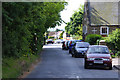
2
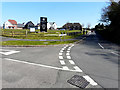
Bakers Field, Cliffs End Road
This was a Image in July 2017. I have used the OS spelling for the road’s name.
Image: © John Baker
Taken: 22 Mar 2020
0.04 miles
3
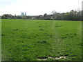
Footpath in Marjorie Chapman Meadow
Leads from Cliffs End Road towards Foads Lane.
In the background are the three chimneys of Richborough disused Power Station.
Image: © David Anstiss
Taken: 10 Apr 2011
0.07 miles
4

Railway bridge over Hengist Way, Cliffsend
The road is built in a cutting for around a mile, while the railway is on the original ground level.
Image: © David Howard
Taken: 31 Jul 2016
0.09 miles
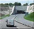
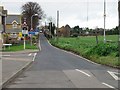
5

East Kent Access Road
The new road emerges from a tunnel east of Foads Lane.
Image: © Burgess Von Thunen
Taken: 3 Jul 2012
0.09 miles
6

Hengist Way, Cliffsend
The railway bridge is ahead
Image: © David Howard
Taken: 31 Jul 2016
0.10 miles
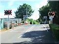
7
Hengist Way, Cliff's End
A short tunnel takes the A299 under the railway line.
Image: © David Dixon
Taken: 16 May 2013
0.10 miles
8
Foads Lane, Cliffsend, Thanet, Kent
A view of Foads Lane looking towards the Cottington Road junction.
The parish church is on the right of the picture
Image: © david mills
Taken: 20 May 2007
0.10 miles
9
Looking up Foads Hill from junction with Cliffs End Road.
Image: © Nick Smith
Taken: 13 Jan 2007
0.11 miles