IMAGES TAKEN NEAR TO
Hazell Mews, RAMSGATE, CT12 5FU
Introduction
This page details the photographs taken nearby to Hazell Mews, CT12 5FU by members of the Geograph project.
The Geograph project started in 2005 with the aim of publishing, organising and preserving representative images for every square kilometre of Great Britain, Ireland and the Isle of Man.

There are currently over 7.5m images from over14,400 individuals and you can help contribute to the project by visiting https://www.geograph.org.uk
Image Map
Images are licensed for reuse under creativecommons.org/licenses/by-sa/2.0
Notes
- Clicking on the map will re-center to the selected point.
- The higher the marker number, the further away the image location is from the centre of the postcode.
Image Listing (4 Images Found)
Images are licensed for reuse under creativecommons.org/licenses/by-sa/2.0
Image
Details
Distance
1
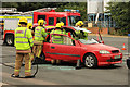
RTA rescue demonstration
Graduates of RAF Recruit Firefighter Course 01-15 demonstrate their skills in dealing with a simulated Road Traffic Accident at the Defence Fire Training and Development Centre, Manston https://www.gov.uk/government/publications/defence-fire-training-and-development-centre/defence-fire-training-and-development-centre
Image: © Richard Croft
Taken: 14 Aug 2015
0.10 miles
2
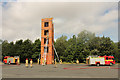
Fire drill
Graduates of RAF Recruit Firefighter Course 01-15 demonstrate their skills in tackling a 4th storey fire in the drill tower at the Defence Fire Training and Development Centre, Manston https://www.gov.uk/government/publications/defence-fire-training-and-development-centre/defence-fire-training-and-development-centre
Image: © Richard Croft
Taken: 14 Aug 2015
0.11 miles