IMAGES TAKEN NEAR TO
Rowes Yard, RAMSGATE, CT12 5FA
Introduction
This page details the photographs taken nearby to Rowes Yard, CT12 5FA by members of the Geograph project.
The Geograph project started in 2005 with the aim of publishing, organising and preserving representative images for every square kilometre of Great Britain, Ireland and the Isle of Man.

There are currently over 7.5m images from over14,400 individuals and you can help contribute to the project by visiting https://www.geograph.org.uk
Image Map
Images are licensed for reuse under creativecommons.org/licenses/by-sa/2.0
Notes
- Clicking on the map will re-center to the selected point.
- The higher the marker number, the further away the image location is from the centre of the postcode.
Image Listing (12 Images Found)
Images are licensed for reuse under creativecommons.org/licenses/by-sa/2.0
Image
Details
Distance
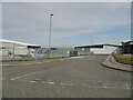
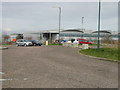
2
Columbus Avenue, Manston
Currently the last roundabout on Columbus Avenue, a site which will soon be further developed.
Image: © Nick Smith
Taken: 24 Mar 2008
0.13 miles
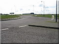
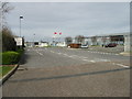
3
Roundabout on Columbus Avenue
Obviously lots of scope for future development and new buildings are going up like this one in the background.
Image: © Nick Smith
Taken: 24 Mar 2008
0.13 miles
4
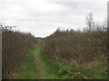
Footpath around Manston Park
A path leads from Minster Road near Cleve Court Farm, around the industrial estate heading towards the B2056 Manston Road.
Image: © David Anstiss
Taken: 6 Feb 2011
0.14 miles
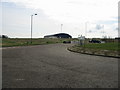
5
The end of Columbus Avenue - for now!
Columbus Avenue is a feeder road for some industrial units, the concrete blocks across the end of the avenue indicate it might be expanding.
Image: © Nick Smith
Taken: 24 Mar 2008
0.15 miles
6
Entrance to Cummins Generators plant, Columbus Avenue
Image: © Nick Smith
Taken: 24 Mar 2008
0.16 miles
7
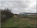
Track to Columbus Avenue
This track leads from the footpath around Manston Park towards a road in the industrial estate.
Image: © David Anstiss
Taken: 6 Feb 2011
0.17 miles
9
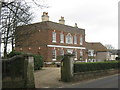
Cleve Court
Grade II Listed building on Minster Road. Built in 17th Century.
See http://www.britishlistedbuildings.co.uk/en-420391-cleve-court-and-cleve-lodge-monkton for more details about the building.
Image: © David Anstiss
Taken: 6 Feb 2011
0.18 miles
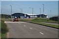
10
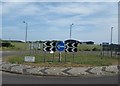
Roundabout on Spitfire Way
This junction is on the B2190 leading from the B2048 Manston Road towards the B2050 Manston Road. Columbus Avenue leads left into Manston Park Industrial Estate.
Image: © David Anstiss
Taken: 23 May 2011
0.19 miles