IMAGES TAKEN NEAR TO
Clive Road, RAMSGATE, CT12 5EG
Introduction
This page details the photographs taken nearby to Clive Road, CT12 5EG by members of the Geograph project.
The Geograph project started in 2005 with the aim of publishing, organising and preserving representative images for every square kilometre of Great Britain, Ireland and the Isle of Man.

There are currently over 7.5m images from over14,400 individuals and you can help contribute to the project by visiting https://www.geograph.org.uk
Image Map
Images are licensed for reuse under creativecommons.org/licenses/by-sa/2.0
Notes
- Clicking on the map will re-center to the selected point.
- The higher the marker number, the further away the image location is from the centre of the postcode.
Image Listing (29 Images Found)
Images are licensed for reuse under creativecommons.org/licenses/by-sa/2.0
Image
Details
Distance
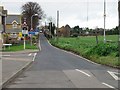
3
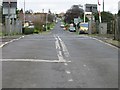
View of Foads Hill from the railway crossing.
Image: © Nick Smith
Taken: 13 Jan 2007
0.07 miles
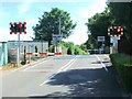
5

Ashford to Ramsgate line
Looking west along the Southeastern-operated line at the level crossing on Foads Lane.
Image: © Burgess Von Thunen
Taken: 3 Jul 2012
0.07 miles
6
Looking up Foads Hill from junction with Cliffs End Road.
Image: © Nick Smith
Taken: 13 Jan 2007
0.07 miles
8

Farmland near Cliffs End
Looking towards the new East Kent Access Road.
Image: © Burgess Von Thunen
Taken: 3 Jul 2012
0.08 miles
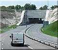
9

East Kent Access Road
The new road goes through a tunnel at Cliffs End.
Image: © Burgess Von Thunen
Taken: 3 Jul 2012
0.08 miles
10
Hengist Way, Cliff's End
A short tunnel takes the A299 under the railway line.
Image: © David Dixon
Taken: 16 May 2013
0.09 miles