IMAGES TAKEN NEAR TO
Preston Road, RAMSGATE, CT12 5AS
Introduction
This page details the photographs taken nearby to Preston Road, CT12 5AS by members of the Geograph project.
The Geograph project started in 2005 with the aim of publishing, organising and preserving representative images for every square kilometre of Great Britain, Ireland and the Isle of Man.

There are currently over 7.5m images from over14,400 individuals and you can help contribute to the project by visiting https://www.geograph.org.uk
Image Map
Images are licensed for reuse under creativecommons.org/licenses/by-sa/2.0
Notes
- Clicking on the map will re-center to the selected point.
- The higher the marker number, the further away the image location is from the centre of the postcode.
Image Listing (28 Images Found)
Images are licensed for reuse under creativecommons.org/licenses/by-sa/2.0
Image
Details
Distance
1
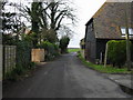
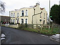
Looking NW along Preston Road
View along Preston Road the buildings are part of Preston Farm
Image: © Nick Smith
Taken: 9 Mar 2008
0.02 miles

10
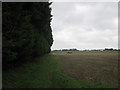
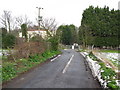
Footpath to Coldswood Farm
A path leads from Preston Road towards another path from Spratling Street to Manston Court Farm. It pasess by Manston Grange (protected/hidden by the trees on the left).
Image: © David Anstiss
Taken: 6 Feb 2011
0.09 miles