IMAGES TAKEN NEAR TO
Willetts Hill, RAMSGATE, CT12 4LJ
Introduction
This page details the photographs taken nearby to Willetts Hill, CT12 4LJ by members of the Geograph project.
The Geograph project started in 2005 with the aim of publishing, organising and preserving representative images for every square kilometre of Great Britain, Ireland and the Isle of Man.

There are currently over 7.5m images from over14,400 individuals and you can help contribute to the project by visiting https://www.geograph.org.uk
Image Map
Images are licensed for reuse under creativecommons.org/licenses/by-sa/2.0
Notes
- Clicking on the map will re-center to the selected point.
- The higher the marker number, the further away the image location is from the centre of the postcode.
Image Listing (48 Images Found)
Images are licensed for reuse under creativecommons.org/licenses/by-sa/2.0
Image
Details
Distance
2

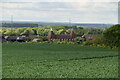
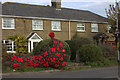
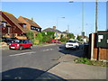
Looking east-southeast along Monkton Street
The sign attached to the nearest lamppost points to the recreation ground.
Image: © John Baker
Taken: 11 Dec 2013
0.05 miles
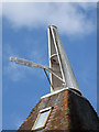
4
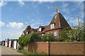
Parsonage Oast, Collards Close, Monkton, Kent
Image: © Oast House Archive
Taken: 16 Aug 2008
0.05 miles
6
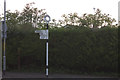
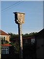
Signpost at junction of Willetts Hill and Monkton Street
Image: © Robert Eva
Taken: 4 Nov 2018
0.06 miles
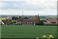
7
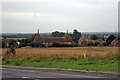
Monkton Street from road to recreation ground
Image: © Nick Smith
Taken: 13 Sep 2008
0.06 miles