IMAGES TAKEN NEAR TO
Laurensfield, RAMSGATE, CT12 4AE
Introduction
This page details the photographs taken nearby to Laurensfield, CT12 4AE by members of the Geograph project.
The Geograph project started in 2005 with the aim of publishing, organising and preserving representative images for every square kilometre of Great Britain, Ireland and the Isle of Man.

There are currently over 7.5m images from over14,400 individuals and you can help contribute to the project by visiting https://www.geograph.org.uk
Image Map
Images are licensed for reuse under creativecommons.org/licenses/by-sa/2.0
Notes
- Clicking on the map will re-center to the selected point.
- The higher the marker number, the further away the image location is from the centre of the postcode.
Image Listing (47 Images Found)
Images are licensed for reuse under creativecommons.org/licenses/by-sa/2.0
Image
Details
Distance
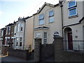
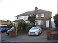
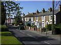
3
Row of cottages at the junction of Orchard Close and Tothill Street, Minster.
Image: © Nick Smith
Taken: 13 Jan 2007
0.03 miles

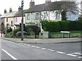
7
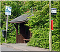
Bus shelter - Minster-in-Thanet
Despite the sign, the bus shelter is not for sale.
Image: © The Carlisle Kid
Taken: 18 Jun 2013
0.06 miles
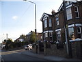
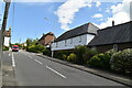
9
Cottages in Tothill Street, Minster, Thanet, Kent
The footpath to Brockman's Close and Orchard Close can be seen on the right by the safety barrier.
Image: © david mills
Taken: 22 Apr 2007
0.07 miles