IMAGES TAKEN NEAR TO
Barton Road, CANTERBURY, CT1 1YH
Introduction
This page details the photographs taken nearby to Barton Road, CT1 1YH by members of the Geograph project.
The Geograph project started in 2005 with the aim of publishing, organising and preserving representative images for every square kilometre of Great Britain, Ireland and the Isle of Man.

There are currently over 7.5m images from over14,400 individuals and you can help contribute to the project by visiting https://www.geograph.org.uk
Image Map
Images are licensed for reuse under creativecommons.org/licenses/by-sa/2.0
Notes
- Clicking on the map will re-center to the selected point.
- The higher the marker number, the further away the image location is from the centre of the postcode.
Image Listing (22 Images Found)
Images are licensed for reuse under creativecommons.org/licenses/by-sa/2.0
Image
Details
Distance
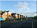
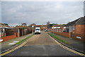
4
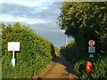
The end of Pilgrims' Way
The North Downs Way leaves Canterbury.
Image: © N Chadwick
Taken: 13 Jan 2013
0.08 miles
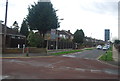
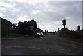
6
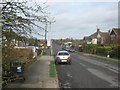
The North Downs Way meets the Pilgrims Way
The long distance path (and the Elham Valley Way) head from Barton Farm towards Canterbury. They go along an urban road in the city. Canterbury Cathedral is seen in the background.
Image: © David Anstiss
Taken: 26 Mar 2010
0.09 miles