IMAGES TAKEN NEAR TO
St. Augustines Road, CANTERBURY, CT1 1XP
Introduction
This page details the photographs taken nearby to St. Augustines Road, CT1 1XP by members of the Geograph project.
The Geograph project started in 2005 with the aim of publishing, organising and preserving representative images for every square kilometre of Great Britain, Ireland and the Isle of Man.

There are currently over 7.5m images from over14,400 individuals and you can help contribute to the project by visiting https://www.geograph.org.uk
Image Map
Images are licensed for reuse under creativecommons.org/licenses/by-sa/2.0
Notes
- Clicking on the map will re-center to the selected point.
- The higher the marker number, the further away the image location is from the centre of the postcode.
Image Listing (111 Images Found)
Images are licensed for reuse under creativecommons.org/licenses/by-sa/2.0
Image
Details
Distance
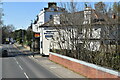
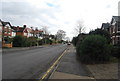
2
Footpath on St. Augustine's Road
This path leads to the Pilgrim's Way. The road leads also to the Pilgrim's Way as well, but more east
Image: © David Anstiss
Taken: 26 Mar 2010
0.03 miles
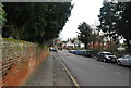
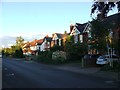
7
St. Augustine's Road
Looking along a street in Canterbury.
Image: © DS Pugh
Taken: 20 Aug 2019
0.08 miles
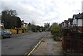
8
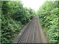
The railway looking north-east, from a bridge on the New Dover Road, Canterbury
Image: © Ruth Sharville
Taken: 12 Jun 2022
0.09 miles
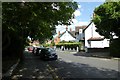
9
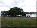
University of Creative Arts, Canterbury
Image: © Chris Whippet
Taken: 4 Sep 2009
0.09 miles