IMAGES TAKEN NEAR TO
Starle Close, CANTERBURY, CT1 1XE
Introduction
This page details the photographs taken nearby to Starle Close, CT1 1XE by members of the Geograph project.
The Geograph project started in 2005 with the aim of publishing, organising and preserving representative images for every square kilometre of Great Britain, Ireland and the Isle of Man.

There are currently over 7.5m images from over14,400 individuals and you can help contribute to the project by visiting https://www.geograph.org.uk
Image Map (Loading...)


Getting Data...Please wait
Leaflet Map data © OpenStreetMap
Images are licensed for reuse under creativecommons.org/licenses/by-sa/2.0
Notes
- Clicking on the map will re-center to the selected point.
- The higher the marker number, the further away the image location is from the centre of the postcode.
Image Listing (101 Images Found)
Images are licensed for reuse under creativecommons.org/licenses/by-sa/2.0
Image
Details
Distance
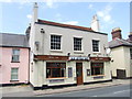
2
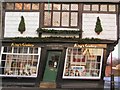
Tipsy
One over the eight? No, this door has been cut to accommodate the settlement of this quaint old building over the centuries.
Image: © Roger May
Taken: 29 Nov 2003
0.05 miles
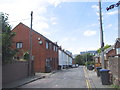
3
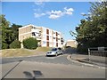
Stable Close, Canterbury
At the junction of Sturry Road
Image: © David Howard
Taken: 31 Jul 2016
0.05 miles
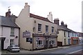
4
Run of the Mill, Canterbury
Known as the Waterloo Tavern until 1986.
Image: © Chris Whippet
Taken: 30 Jun 2014
0.07 miles
5
Run of the Mill Public House, Canterbury
On Sturry Road.
Image: © David Anstiss
Taken: 30 Sep 2009
0.07 miles
6
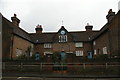
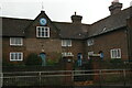
Jesus Hospital: almshouses, Sturry Road, Canterbury
Image: © Christopher Hilton
Taken: 26 Nov 2018
0.07 miles
7
Jesus Hospital: almshouses, Sturry Road, Canterbury
Image: © Christopher Hilton
Taken: 26 Nov 2018
0.07 miles