IMAGES TAKEN NEAR TO
Lower Chantry Lane, CANTERBURY, CT1 1UF
Introduction
This page details the photographs taken nearby to Lower Chantry Lane, CT1 1UF by members of the Geograph project.
The Geograph project started in 2005 with the aim of publishing, organising and preserving representative images for every square kilometre of Great Britain, Ireland and the Isle of Man.

There are currently over 7.5m images from over14,400 individuals and you can help contribute to the project by visiting https://www.geograph.org.uk
Image Map
Images are licensed for reuse under creativecommons.org/licenses/by-sa/2.0
Notes
- Clicking on the map will re-center to the selected point.
- The higher the marker number, the further away the image location is from the centre of the postcode.
Image Listing (578 Images Found)
Images are licensed for reuse under creativecommons.org/licenses/by-sa/2.0
Image
Details
Distance

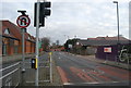
2
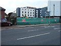
Building site, Lower Chantry Lane
This site used to be The Chantry Club (at number 12).
Planning permission has been granted by Canterbury City Council under application number CA//15/02154 for “details submitted pursuant to condition 07 (hard and soft landscape works, disabled car parking layouts; access and circulation areas; hard surfacing materials; minor artefacts and structures for refuse, recycling and cycle storage) of the appeal decision APP/J2210/A/14/2212428, planning permission CA/13/01491/FUL”.
The finished building was called Image
Image: © John Baker
Taken: 22 Nov 2015
0.02 miles
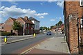
3
Chantry Place, Lower Chantry Lane
This is how the Image looks, now the building has been completed.
Image: © John Baker
Taken: 3 Dec 2017
0.02 miles
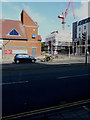
5
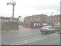
The site of a new Premier Inn
Viewed from Lower Chantry Lane. The removal of part of the hoarding enables one to see how the construction of the building is progressing.
Image: © John Baker
Taken: 10 Mar 2013
0.03 miles
7
Looking east-northeast across St George?s Place
Towards the building under construction, which, in November 2015, was a Image where planning permission has been granted by Canterbury City Council under application number CA//15/02154 for “details submitted pursuant to condition 07 (hard and soft landscape works, disabled car parking layouts; access and circulation areas; hard surfacing materials; minor artefacts and structures for refuse, recycling and cycle storage) of the appeal decision APP/J2210/A/14/2212428, planning permission CA/13/01491/FUL”.
Image: © John Baker
Taken: 18 Sep 2016
0.03 miles
8

Canterbury Cathedral Sunset
Sunset over Canterbury Cathedral
Image: © Peter Ashby
Taken: 20 Jun 2005
0.03 miles
10
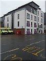
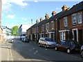
Lower Chantry Lane
Looking along Lower Chantry Lane near Waitrose.
Image: © DS Pugh
Taken: 20 Aug 2019
0.03 miles