IMAGES TAKEN NEAR TO
St. Pauls Terrace, CANTERBURY, CT1 1TY
Introduction
This page details the photographs taken nearby to St. Pauls Terrace, CT1 1TY by members of the Geograph project.
The Geograph project started in 2005 with the aim of publishing, organising and preserving representative images for every square kilometre of Great Britain, Ireland and the Isle of Man.

There are currently over 7.5m images from over14,400 individuals and you can help contribute to the project by visiting https://www.geograph.org.uk
Image Map
Images are licensed for reuse under creativecommons.org/licenses/by-sa/2.0
Notes
- Clicking on the map will re-center to the selected point.
- The higher the marker number, the further away the image location is from the centre of the postcode.
Image Listing (1493 Images Found)
Images are licensed for reuse under creativecommons.org/licenses/by-sa/2.0
Image
Details
Distance
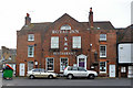
1
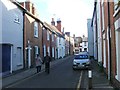
Cantacandy, Love St
Grade II listed. http://www.britishlistedbuildings.co.uk/en-439656-6-canterbury
Image: © N Chadwick
Taken: 14 May 2011
0.01 miles
4
![Canterbury houses [114]](https://s2.geograph.org.uk/geophotos/07/09/35/7093582_88a0f1d1_120x120.jpg)
Canterbury houses [114]
Numbers 7 to 13 Love Lane are an early 19th century terrace of 7 houses. Constructed of red brick, some painted, one pebbledashed, under hipped tile roofs. Listed, grade II, with details at: https://historicengland.org.uk/listing/the-list/list-entry/1334322
Canterbury is a small historic city on the River Stour in Kent, some 54 miles southeast of London. Occupied since prehistoric times, it became an important Roman city. In 672, the see of Canterbury gained authority over the entire English Church. After the murder of Archbishop Thomas Becket at the cathedral in 1170, pilgrims from all parts of Christendom came to visit his shrine until the Dissolution. Today, Canterbury is a popular tourist destination and one of the most-visited cities in the United Kingdom. The city has a substantial student population, with four university campuses.
Image: © Michael Dibb
Taken: 7 Sep 2021
0.02 miles
5
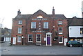
Royal Inn Restaurant
Formerly known as Longport House. Grade II listed. http://www.britishlistedbuildings.co.uk/en-439655-longport-house-1-3-canterbury
Image: © N Chadwick
Taken: 7 Jan 2012
0.02 miles
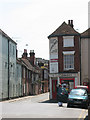
6
Royal Inn Restaurant, Canterbury
A late 18th century grade II listed building, the block as a whole listed as Longport House, 1-3 Longport.
Image: © Robin Webster
Taken: 28 Dec 2015
0.02 miles
7
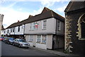
Carolean Cottage
Grade II listed. http://www.britishlistedbuildings.co.uk/en-439376-carolean-cottage-7-canterbury
Image: © N Chadwick
Taken: 7 Jan 2012
0.02 miles
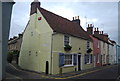
8
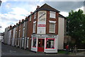
Cantacandy
A sweet shop on the corner of Love Lane. Presumably its historic advertisement has been allowed an exemption from the more recent ban on tobacco advertising.
Image: © Stephen Craven
Taken: 25 Oct 2014
0.02 miles
9
![Canterbury churches [76]](https://s0.geograph.org.uk/geophotos/07/09/19/7091976_9c038806_120x120.jpg)
Canterbury churches [76]
This house and shop at number 6 Longport, was built in the early 19th century with a rounded corner. Constructed of red brick under a hipped tile roof. Listed, grade II, with details at: https://historicengland.org.uk/listing/the-list/list-entry/1260739
Canterbury is a small historic city on the River Stour in Kent, some 54 miles southeast of London. Occupied since prehistoric times, it became an important Roman city. In 672, the see of Canterbury gained authority over the entire English Church. After the murder of Archbishop Thomas Becket at the cathedral in 1170, pilgrims from all parts of Christendom came to visit his shrine until the Dissolution. Today, Canterbury is a popular tourist destination and one of the most-visited cities in the United Kingdom. The city has a substantial student population, with four university campuses.
Image: © Michael Dibb
Taken: 7 Sep 2021
0.02 miles
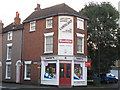
10
Candy shop, Love Lane, Canterbury
The shop is on the corner at the northern end of Love Lane (the narrow street in the background).
Image: © Stephen Craven
Taken: 4 Jul 2009
0.02 miles