IMAGES TAKEN NEAR TO
Kings Mews, St. Johns Place, CANTERBURY, CT1 1RB
Introduction
This page details the photographs taken nearby to Kings Mews, St. Johns Place, CT1 1RB by members of the Geograph project.
The Geograph project started in 2005 with the aim of publishing, organising and preserving representative images for every square kilometre of Great Britain, Ireland and the Isle of Man.

There are currently over 7.5m images from over14,400 individuals and you can help contribute to the project by visiting https://www.geograph.org.uk
Image Map
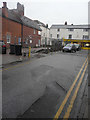
Images are licensed for reuse under creativecommons.org/licenses/by-sa/2.0
Notes
- Clicking on the map will re-center to the selected point.
- The higher the marker number, the further away the image location is from the centre of the postcode.
Image Listing (1103 Images Found)
Images are licensed for reuse under creativecommons.org/licenses/by-sa/2.0
Image
Details
Distance
1
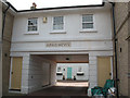
King's Mews, St John's Place
A contemporary mews courtyard on a side street off Northgate, Canterbury.
Image: © Stephen Craven
Taken: 17 Jun 2010
0.01 miles
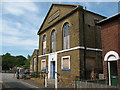
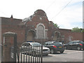
3
St John?s Hall, St John?s Place
Planning permission has been granted by Canterbury City Council under application number CA//16/01249 for the “conversion of St John's Hall to dwelling with replacement annexe to side, and erection of 3 two-storey terraced dwellings with rooms in the roof space”.
Image: © John Baker
Taken: 3 Dec 2017
0.01 miles
4
![Canterbury buildings [162]](https://s0.geograph.org.uk/geophotos/07/10/22/7102296_f62f223e_120x120.jpg)
Canterbury buildings [162]
St John's Hall, St John's Place, was originally a Methodist chapel, built in 1839. Converted into a boys' school in 1875, the school closed in 2008. Now a private residence. Constructed of buff brick with ashlar dressings. Listed, grade II, with details at: https://historicengland.org.uk/listing/the-list/list-entry/1241918
Canterbury is a small historic city on the River Stour in Kent, some 54 miles southeast of London. Occupied since prehistoric times, it became an important Roman city. In 672, the see of Canterbury gained authority over the entire English Church. After the murder of Archbishop Thomas Becket at the cathedral in 1170, pilgrims from all parts of Christendom came to visit his shrine until the Dissolution. Today, Canterbury is a popular tourist destination and one of the most-visited cities in the United Kingdom. The city has a substantial student population, with four university campuses.
Image: © Michael Dibb
Taken: 12 Sep 2021
0.01 miles
5
Former St John's school
This building on St John's Place, bears the inscription "St John's Board School 1876". Presumably it was superseded by the adjacent Kingsmead School. It appeared unoccupied as of 2010, though an access ramp had been built in recent years.
Image: © Stephen Craven
Taken: 17 Jun 2010
0.01 miles
6
![Canterbury houses [197]](https://s3.geograph.org.uk/geophotos/07/10/22/7102299_684e7565_120x120.jpg)
Canterbury houses [197]
Number 10 St John's Place is an early 19th century house. Constructed of red brick under a tile roof. Listed, grade II, with details at: https://historicengland.org.uk/listing/the-list/list-entry/1260240
Canterbury is a small historic city on the River Stour in Kent, some 54 miles southeast of London. Occupied since prehistoric times, it became an important Roman city. In 672, the see of Canterbury gained authority over the entire English Church. After the murder of Archbishop Thomas Becket at the cathedral in 1170, pilgrims from all parts of Christendom came to visit his shrine until the Dissolution. Today, Canterbury is a popular tourist destination and one of the most-visited cities in the United Kingdom. The city has a substantial student population, with four university campuses.
Image: © Michael Dibb
Taken: 12 Sep 2021
0.01 miles
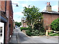
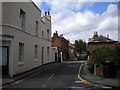
7
St John?s Place
For some reason an area of tarmac has been excavated and the area surrounded by a wire fence.
Image: © John Baker
Taken: 3 Dec 2017
0.02 miles
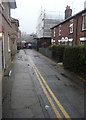
8
St John's Place, Canterbury
Seen from Northgate.
Image: © Richard Vince
Taken: 25 Aug 2012
0.02 miles
9
Derelict building off St John's Place
The building is in the grounds of Kingsmead School (the photo was taken from the entrance to the school car park) and bears a date stone 1900, but its original function was not apparent.
Image: © Stephen Craven
Taken: 17 Jun 2010
0.03 miles
10
![Canterbury buildings [141]](https://s1.geograph.org.uk/geophotos/07/10/13/7101381_5a2ca9d0_120x120.jpg)
Canterbury buildings [141]
Number 58 Northgate and number 11 St John's Place were built in the early 19th century of painted brick. Listed, grade II, with details at: https://historicengland.org.uk/listing/the-list/list-entry/1241062
Canterbury is a small historic city on the River Stour in Kent, some 54 miles southeast of London. Occupied since prehistoric times, it became an important Roman city. In 672, the see of Canterbury gained authority over the entire English Church. After the murder of Archbishop Thomas Becket at the cathedral in 1170, pilgrims from all parts of Christendom came to visit his shrine until the Dissolution. Today, Canterbury is a popular tourist destination and one of the most-visited cities in the United Kingdom. The city has a substantial student population, with four university campuses.
Image: © Michael Dibb
Taken: 12 Sep 2021
0.03 miles