IMAGES TAKEN NEAR TO
Old Ruttington Lane, CANTERBURY, CT1 1NY
Introduction
This page details the photographs taken nearby to Old Ruttington Lane, CT1 1NY by members of the Geograph project.
The Geograph project started in 2005 with the aim of publishing, organising and preserving representative images for every square kilometre of Great Britain, Ireland and the Isle of Man.

There are currently over 7.5m images from over14,400 individuals and you can help contribute to the project by visiting https://www.geograph.org.uk
Image Map
Images are licensed for reuse under creativecommons.org/licenses/by-sa/2.0
Notes
- Clicking on the map will re-center to the selected point.
- The higher the marker number, the further away the image location is from the centre of the postcode.
Image Listing (650 Images Found)
Images are licensed for reuse under creativecommons.org/licenses/by-sa/2.0
Image
Details
Distance
1
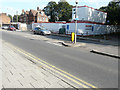
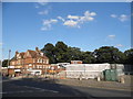
Redevelopment of the former Canterbury Ambulance Station, Military Road
Planning permission has been granted by Canterbury City Council under application number CA//15/02311 for the “demolition of the existing buildings and the erection of 8 houses and 6, two-bedroom flats with associated car parking and the re-landscaping of adjoining open area”. Stephen Craven’s view of Image also shows the ambulance station.
Image: © John Baker
Taken: 18 Sep 2016
0.01 miles
2
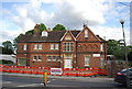
Victorian building, Military St
Dated to 1879
Image: © N Chadwick
Taken: 14 May 2011
0.02 miles
3

Ongoing redevelopment of former Canterbury Ambulance Station, Military Road
Planning permission was granted by Canterbury City Council under application number CA//15/02311 for the “demolition of the existing buildings and the erection of 8 houses and 6 two-bedroom flats with associated car parking and the re-landscaping of adjoining open area”.
This view of the Image was taken during my last visit.
Image: © John Baker
Taken: 21 May 2017
0.02 miles
4
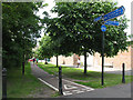
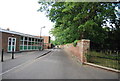
Cycleway on North Holmes Road
The continuation of North Holmes Road beyond its junction with Old Ruttington Lane takes the form of a cycleway, signposted to Northgate (and in the opposite direction to Christ Church University).
Image: © Stephen Craven
Taken: 17 Jun 2010
0.02 miles
5
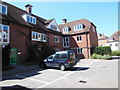
Student accommodation, Lanfranc House
Part of Canterbury Christ Church University and tucked away just off Northgate. Something of an architectural mix but using local materials and style.
Image: © HelenK
Taken: 31 Aug 2013
0.02 miles
6
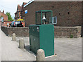
Air quality monitor, Military Road
An air quality monitoring station outside the ambulance station on Military Road (A28), Canterbury.
Image: © Stephen Craven
Taken: 17 Jun 2010
0.03 miles
7
Demolished ambulance station on Military Road
Lyon's 24 hour funeral service is on the left.
Image: © David Howard
Taken: 31 Jul 2016
0.03 miles
8
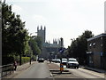
Canterbury, Military Road
Canterbury, Military Road, A28. Canterbury Cathedral visible in the distance.
Image: © Helmut Zozmann
Taken: 28 Jul 2011
0.03 miles
10
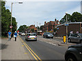
Military Road, Canterbury
Looking north-east along Military Road (the A28). The brick building on the right of the photo is an ambulance station, and the "yellow box" road markings warning traffic lights for it can also be seen.
Image: © Stephen Craven
Taken: 17 Jun 2010
0.03 miles