IMAGES TAKEN NEAR TO
Union Street, CANTERBURY, CT1 1LP
Introduction
This page details the photographs taken nearby to Union Street, CT1 1LP by members of the Geograph project.
The Geograph project started in 2005 with the aim of publishing, organising and preserving representative images for every square kilometre of Great Britain, Ireland and the Isle of Man.

There are currently over 7.5m images from over14,400 individuals and you can help contribute to the project by visiting https://www.geograph.org.uk
Image Map
Images are licensed for reuse under creativecommons.org/licenses/by-sa/2.0
Notes
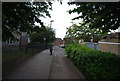
- Clicking on the map will re-center to the selected point.
- The higher the marker number, the further away the image location is from the centre of the postcode.
Image Listing (506 Images Found)
Images are licensed for reuse under creativecommons.org/licenses/by-sa/2.0
Image
Details
Distance
2
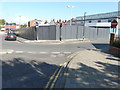
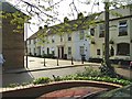
Northgate Garage, Northgate
Seen from Union Street, planning permission has been registered by Canterbury City Council under application number CA//19/01463 for the “proposed erection of 35 self-contained flats with underground parking and access, following demolition of the existing building”.
The garage dealt in selling and servicing Fiat cars.
Image: © John Baker
Taken: 25 Aug 2019
0.05 miles
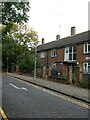
4
![Canterbury buildings [163]](https://s3.geograph.org.uk/geophotos/07/10/23/7102303_0924f372_120x120.jpg)
Canterbury buildings [163]
Now a private residence, number 64A Union Place is the former King William IV public house which closed in the late 2000s. Built circa 1840 of painted brick under a hipped slate roof. Listed, grade II, with details at: https://historicengland.org.uk/listing/the-list/list-entry/1242768
Canterbury is a small historic city on the River Stour in Kent, some 54 miles southeast of London. Occupied since prehistoric times, it became an important Roman city. In 672, the see of Canterbury gained authority over the entire English Church. After the murder of Archbishop Thomas Becket at the cathedral in 1170, pilgrims from all parts of Christendom came to visit his shrine until the Dissolution. Today, Canterbury is a popular tourist destination and one of the most-visited cities in the United Kingdom. The city has a substantial student population, with four university campuses.
Image: © Michael Dibb
Taken: 12 Sep 2021
0.05 miles
5
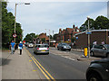
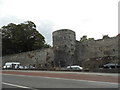
Military Road, Canterbury
Looking north-east along Military Road (the A28). The brick building on the right of the photo is an ambulance station, and the "yellow box" road markings warning traffic lights for it can also be seen.
Image: © Stephen Craven
Taken: 17 Jun 2010
0.05 miles
6
Near Military Road
Recently built houses
Image: © Simon Richardson
Taken: 25 Apr 2007
0.05 miles
8
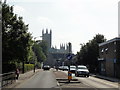
Canterbury, Military Road
Canterbury, Military Road, A28. Canterbury Cathedral visible in the distance.
Image: © Helmut Zozmann
Taken: 28 Jul 2011
0.06 miles
9
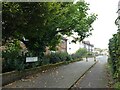
Looking from Military Road into New Ruttington Lane
Image: © Basher Eyre
Taken: 23 Sep 2024
0.06 miles
10
![Canterbury houses [196]](https://s2.geograph.org.uk/geophotos/07/10/16/7101698_da44f498_120x120.jpg)
Canterbury houses [196]
Numbers 113 and 114 Northgate are a pair of 16th century houses. Timber framed, plastered, jettied to the street, the ground floor rebuilt in brick, all under a tile roof. Listed, grade II, with details at: https://historicengland.org.uk/listing/the-list/list-entry/1241116
Canterbury is a small historic city on the River Stour in Kent, some 54 miles southeast of London. Occupied since prehistoric times, it became an important Roman city. In 672, the see of Canterbury gained authority over the entire English Church. After the murder of Archbishop Thomas Becket at the cathedral in 1170, pilgrims from all parts of Christendom came to visit his shrine until the Dissolution. Today, Canterbury is a popular tourist destination and one of the most-visited cities in the United Kingdom. The city has a substantial student population, with four university campuses.
Image: © Michael Dibb
Taken: 12 Sep 2021
0.06 miles