IMAGES TAKEN NEAR TO
Sturry Road, CANTERBURY, CT1 1HT
Introduction
This page details the photographs taken nearby to Sturry Road, CT1 1HT by members of the Geograph project.
The Geograph project started in 2005 with the aim of publishing, organising and preserving representative images for every square kilometre of Great Britain, Ireland and the Isle of Man.

There are currently over 7.5m images from over14,400 individuals and you can help contribute to the project by visiting https://www.geograph.org.uk
Image Map
Images are licensed for reuse under creativecommons.org/licenses/by-sa/2.0
Notes
- Clicking on the map will re-center to the selected point.
- The higher the marker number, the further away the image location is from the centre of the postcode.
Image Listing (47 Images Found)
Images are licensed for reuse under creativecommons.org/licenses/by-sa/2.0
Image
Details
Distance
3
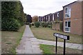
Mary Green Walk, Canterbury
This footpath leads from Sturry Road to Hudson Road.
Image: © David Anstiss
Taken: 30 Sep 2009
0.05 miles
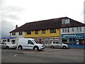
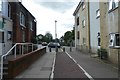
4
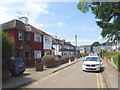
Sturry Road looking towards Mary Green Walk
Image: © David Howard
Taken: 31 Jul 2016
0.05 miles
5
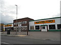
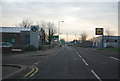
Watling Tyres on Sturry Road, Canterbury
Image: © David Howard
Taken: 31 Jul 2016
0.05 miles
6
Long grass near Barton Mill Road
Looking across a field beside Sargeants Parade.
Image: © DS Pugh
Taken: 20 Aug 2019
0.09 miles
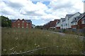
9
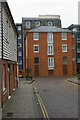
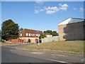
Canterbury: new housing on Barton Mill Road
The housing here stems from the redevelopment of the former Barton Mill, straddling the Stour.
Image: © Christopher Hilton
Taken: 26 Nov 2018
0.12 miles
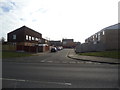
10
Path to Military Road
Linking through from Brymore Road.
Image: © DS Pugh
Taken: 20 Aug 2019
0.12 miles