IMAGES TAKEN NEAR TO
Havelock Street, CANTERBURY, CT1 1HB
Introduction
This page details the photographs taken nearby to Havelock Street, CT1 1HB by members of the Geograph project.
The Geograph project started in 2005 with the aim of publishing, organising and preserving representative images for every square kilometre of Great Britain, Ireland and the Isle of Man.

There are currently over 7.5m images from over14,400 individuals and you can help contribute to the project by visiting https://www.geograph.org.uk
Image Map
Images are licensed for reuse under creativecommons.org/licenses/by-sa/2.0
Notes
- Clicking on the map will re-center to the selected point.
- The higher the marker number, the further away the image location is from the centre of the postcode.
Image Listing (1314 Images Found)
Images are licensed for reuse under creativecommons.org/licenses/by-sa/2.0
Image
Details
Distance

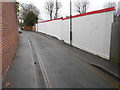
2
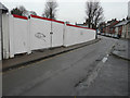
Hoarding, Havelock Street
Planning permission has been granted by Canterbury City Council under application number CA//17/01420 for the “proposed erection of 3 terraced two-storey dwellings with accommodation in the roof space, 1 two-storey building with accommodation in the roof space to create [a] 1 two-bed flat, detached three-storey building comprising 21 units of student accommodation with warden accommodation, with cycle and refuse storage facilities following demolition of existing buildings together with first floor rear extension to 42 Broad Street, together with external alterations and pitched roof to rear of 41 Broad Street”.
The Image is on the other side of the site.
Image: © John Baker
Taken: 3 Dec 2017
0.01 miles
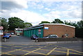
5
Hoarding, Old Ruttington Lane
Planning permission has been granted by Canterbury City Council under application number CA//17/01420 for the “proposed erection of 3 terraced two-storey dwellings with accommodation in the roof space, 1 two-storey building with accommodation in the roof space to create [a] 1 two-bed flat, detached three-storey building comprising 21 units of student accommodation with warden accommodation, with cycle and refuse storage facilities following demolition of existing buildings together with first floor rear extension to 42 Broad Street, together with external alterations and pitched roof to rear of 41 Broad Street”.
The Image is on the other side of the site, where there used to be a Image This was previously used as an annex to the adjoining former Diocesan & Payne Smith Primary School.
Image: © John Baker
Taken: 3 Dec 2017
0.02 miles
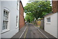
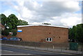
7
Derelict building, Old Ruttingdon Lane
On the right is a single storey building with boarded up windows, which seems to indicate that it is not in use.
Image: © John Baker
Taken: 27 Jan 2016
0.02 miles
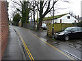
9
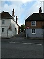
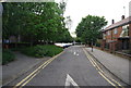
Looking across Broad Street towards Old Ruttington Lane
Image: © Basher Eyre
Taken: 23 Sep 2024
0.02 miles