IMAGES TAKEN NEAR TO
Highlanders Avenue, CANTERBURY, CT1 1GJ
Introduction
This page details the photographs taken nearby to Highlanders Avenue, CT1 1GJ by members of the Geograph project.
The Geograph project started in 2005 with the aim of publishing, organising and preserving representative images for every square kilometre of Great Britain, Ireland and the Isle of Man.

There are currently over 7.5m images from over14,400 individuals and you can help contribute to the project by visiting https://www.geograph.org.uk
Image Map
Images are licensed for reuse under creativecommons.org/licenses/by-sa/2.0
Notes
- Clicking on the map will re-center to the selected point.
- The higher the marker number, the further away the image location is from the centre of the postcode.
Image Listing (39 Images Found)
Images are licensed for reuse under creativecommons.org/licenses/by-sa/2.0
Image
Details
Distance
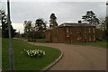
2
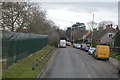
The entrance to St Martin's Hospital, Canterbury
Image: © David Howard
Taken: 22 Jun 2017
0.11 miles
5
Site of Howe Barracks, Littlebourne Road
Planning permission has been granted by Canterbury City Council under application number CA//14/01230 for a hybrid planning application comprising:
1) application for outline planning permission for the demolition of all but three of the Barracks' buildings and the redevelopment of the site for up to 500 dwellings with new formal and informal public spaces and landscaping together with revised access from Littlebourne Road, new parking to Littlebourne Road and a road link connecting Littlebourne Road with Chaucer Road/Military Road.
2) application to change the use of the retained buildings (Gymnasium, Chapel and Small Arms Trainer) to community uses (Use Classes D1 and D2). The application is accompanied by an Environmental Statement submitted pursuant to the Town and Country Planning (Environmental Impact Assessment).
The development is to be known as Royal Parade.
Image: © John Baker
Taken: 18 Feb 2018
0.17 miles
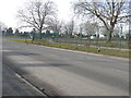
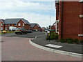
6
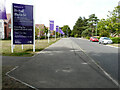
Villiers Road
The development, which has been named Royal Parade, consists of an assortment of apartments and houses, which were built on the site of a Image
Image: © John Baker
Taken: 28 Aug 2022
0.18 miles
7
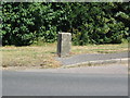
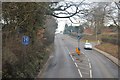
Boundary stone, A257
Marked with the government 'broad arrow' and 'BS WD No. 9'. At the SE end of the barracks on the A257.
Image: © E Gammie
Taken: 8 Jul 2010
0.18 miles
8
The Asylum's taken over the lunatics
Canterbury's former Psychiatric Hospital is now Health Service Offices
Image: © David Long
Taken: 20 Apr 2006
0.19 miles
9
Cotter Way
Part of a development named Grand Parade.
Image: © John Baker
Taken: 23 Jul 2023
0.19 miles
10
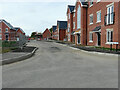
Cotter Way
A road on a development, which has been named Royal Parade.
Image: © John Baker
Taken: 28 Aug 2022
0.19 miles