IMAGES TAKEN NEAR TO
Sturry Road, CANTERBURY, CT1 1DG
Introduction
This page details the photographs taken nearby to Sturry Road, CT1 1DG by members of the Geograph project.
The Geograph project started in 2005 with the aim of publishing, organising and preserving representative images for every square kilometre of Great Britain, Ireland and the Isle of Man.

There are currently over 7.5m images from over14,400 individuals and you can help contribute to the project by visiting https://www.geograph.org.uk
Image Map
Images are licensed for reuse under creativecommons.org/licenses/by-sa/2.0
Notes
- Clicking on the map will re-center to the selected point.
- The higher the marker number, the further away the image location is from the centre of the postcode.
Image Listing (27 Images Found)
Images are licensed for reuse under creativecommons.org/licenses/by-sa/2.0
Image
Details
Distance
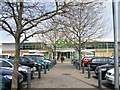
2
Large Supermarket on Sturry Road, Canterbury
Image: © Chris Whippet
Taken: 30 Jun 2014
0.06 miles
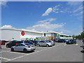
3
Marshwood Close Retail Park, Canterbury
Large warehouse stores (Argos, Paul Simon and Comet). On Marshwood Close.
Image: © David Anstiss
Taken: 30 Sep 2009
0.09 miles
4
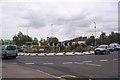
Roundabout on the A28 Sturry Road
The road from Canterbury city centre reaches this junction. A road leads left towards an Asda Superstore and Petrol Garage. A road also leads right towards a B+Q Homewares Store. The Sturry Road also continues on towards Sturry and Fordwich.
Image: © David Anstiss
Taken: 30 Sep 2009
0.10 miles
5
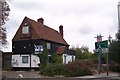
Closed fast food restaurant
This place near the Asda, B+Q Roundabout on the A28 Sturry Road, was a Burger King restaurant, but closed down several years ago. It did not have a drive-through option, so maybe that led to its downfall. Presumably, it was a pub before that. Cheekily, McDonald's have added a sign to their restaurant further up the road.
Image: © David Anstiss
Taken: 30 Sep 2009
0.12 miles
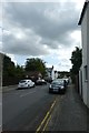
6
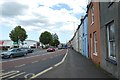
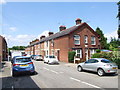
Along Sturry Road
Looking along Sturry Road near South Street.
Image: © DS Pugh
Taken: 20 Aug 2019
0.12 miles
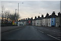
8
South Street
Looking along South Street from Sturry Road.
Image: © DS Pugh
Taken: 20 Aug 2019
0.14 miles
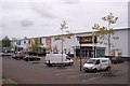
9
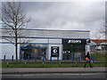
Former Jessops Store, Canterbury
Small store on the A28 Sturry Road, beside a Carphone Warehouse store (still trading! - so people want phones not cameras!).
In the background is a Aldi's store undergoing renovation.
Image: © David Anstiss
Taken: 2 Feb 2013
0.14 miles