IMAGES TAKEN NEAR TO
Jesus Hospital, Sturry Road, CANTERBURY, CT1 1BS
Introduction
This page details the photographs taken nearby to Jesus Hospital, Sturry Road, CT1 1BS by members of the Geograph project.
The Geograph project started in 2005 with the aim of publishing, organising and preserving representative images for every square kilometre of Great Britain, Ireland and the Isle of Man.

There are currently over 7.5m images from over14,400 individuals and you can help contribute to the project by visiting https://www.geograph.org.uk
Image Map
Images are licensed for reuse under creativecommons.org/licenses/by-sa/2.0
Notes
- Clicking on the map will re-center to the selected point.
- The higher the marker number, the further away the image location is from the centre of the postcode.
Image Listing (151 Images Found)
Images are licensed for reuse under creativecommons.org/licenses/by-sa/2.0
Image
Details
Distance
1
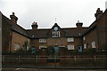
Jesus Hospital: almshouses, Sturry Road, Canterbury
Image: © Christopher Hilton
Taken: 26 Nov 2018
0.01 miles
2
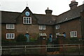
Jesus Hospital: almshouses, Sturry Road, Canterbury
Image: © Christopher Hilton
Taken: 26 Nov 2018
0.01 miles
3
Stable Close, Canterbury
At the junction of Sturry Road
Image: © David Howard
Taken: 31 Jul 2016
0.01 miles
4
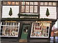
Tipsy
One over the eight? No, this door has been cut to accommodate the settlement of this quaint old building over the centuries.
Image: © Roger May
Taken: 29 Nov 2003
0.02 miles
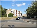
6
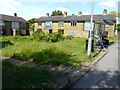
Cold Harbour, Sturry Road
These buildings formed a group of council flats and bedsits.
Image: © John Baker
Taken: 21 May 2017
0.04 miles
8
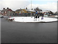
Hoarding, Sturry Road
Possibly erected to stop squatters taking up residence on the derelict site known as Cold Harbour, whose buildings formed a group of council flats and bedsits.
This image of Image shows the site before the hoarding was erected.
Snow, which has fallen courtesy of “the beast from the east”, lay here around a depth of 4” (10 cm).
Image: © John Baker
Taken: 28 Feb 2018
0.06 miles
9
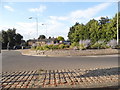
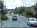
Roundabout on Tourtel Road, Canterbury
Image: © David Howard
Taken: 31 Jul 2016
0.06 miles
10
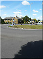
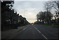
Looking north across a roundabout
Towards Cold Harbour in Sturry Road, whose buildings formed a group of council flats and bedsits but which are now derelict.
Image: © John Baker
Taken: 21 May 2017
0.06 miles