IMAGES TAKEN NEAR TO
High Street St. Gregorys, CANTERBURY, CT1 1AE
Introduction
This page details the photographs taken nearby to High Street St. Gregorys, CT1 1AE by members of the Geograph project.
The Geograph project started in 2005 with the aim of publishing, organising and preserving representative images for every square kilometre of Great Britain, Ireland and the Isle of Man.

There are currently over 7.5m images from over14,400 individuals and you can help contribute to the project by visiting https://www.geograph.org.uk
Image Map
Images are licensed for reuse under creativecommons.org/licenses/by-sa/2.0
Notes
- Clicking on the map will re-center to the selected point.
- The higher the marker number, the further away the image location is from the centre of the postcode.
Image Listing (1051 Images Found)
Images are licensed for reuse under creativecommons.org/licenses/by-sa/2.0
Image
Details
Distance
1
![Canterbury buildings [158]](https://s0.geograph.org.uk/geophotos/07/10/16/7101684_7b235a30_120x120.jpg)
Canterbury buildings [158]
Numbers 90 and 91 Northgate were built in the 18th century in red brick. At one time a public house. Listed, grade II, with details at: https://historicengland.org.uk/listing/the-list/list-entry/1241115
Canterbury is a small historic city on the River Stour in Kent, some 54 miles southeast of London. Occupied since prehistoric times, it became an important Roman city. In 672, the see of Canterbury gained authority over the entire English Church. After the murder of Archbishop Thomas Becket at the cathedral in 1170, pilgrims from all parts of Christendom came to visit his shrine until the Dissolution. Today, Canterbury is a popular tourist destination and one of the most-visited cities in the United Kingdom. The city has a substantial student population, with four university campuses.
Image: © Michael Dibb
Taken: 12 Sep 2021
0.01 miles
2
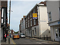
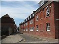
Northgate, Canterbury
A view looking north from the junction with High Street.
Image: © Stephen Craven
Taken: 17 Jun 2010
0.01 miles
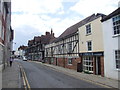
4
![Canterbury buildings [157]](https://s0.geograph.org.uk/geophotos/07/10/16/7101620_87897bcc_120x120.jpg)
Canterbury buildings [157]
Number 89 Northgate, seen here, and numbers 86, 87 and 88 Northgate Image occupy a range of 17th century buildings refronted in, probably, the early 19th century. Timber framed, stuccoed, all under hipped slate roofs. Note the unusual corner window. Listed, grade II, with details at: https://historicengland.org.uk/listing/the-list/list-entry/1241114
Canterbury is a small historic city on the River Stour in Kent, some 54 miles southeast of London. Occupied since prehistoric times, it became an important Roman city. In 672, the see of Canterbury gained authority over the entire English Church. After the murder of Archbishop Thomas Becket at the cathedral in 1170, pilgrims from all parts of Christendom came to visit his shrine until the Dissolution. Today, Canterbury is a popular tourist destination and one of the most-visited cities in the United Kingdom. The city has a substantial student population, with four university campuses.
Image: © Michael Dibb
Taken: 12 Sep 2021
0.01 miles
5
![Canterbury features [53]](https://s0.geograph.org.uk/geophotos/07/10/13/7101380_8b836937_120x120.jpg)
Canterbury features [53]
Between numbers 48 and 49 Northgate is the gatehouse to St John's Hospital. Built in the 16th century, timber framed, plastered, under a tile roof, restored. Listed, grade II*, with details at: https://historicengland.org.uk/listing/the-list/list-entry/1260716
Canterbury is a small historic city on the River Stour in Kent, some 54 miles southeast of London. Occupied since prehistoric times, it became an important Roman city. In 672, the see of Canterbury gained authority over the entire English Church. After the murder of Archbishop Thomas Becket at the cathedral in 1170, pilgrims from all parts of Christendom came to visit his shrine until the Dissolution. Today, Canterbury is a popular tourist destination and one of the most-visited cities in the United Kingdom. The city has a substantial student population, with four university campuses.
Image: © Michael Dibb
Taken: 12 Sep 2021
0.02 miles
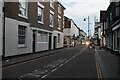
8
High Street, Canterbury
Is this the shortest and/or narrowest High Street in the country? It is only 70m long and barely one vehicle wide at the western end where it meets Northgate. This photo is from the opposite end where it meets Victoria Row.
Image: © Stephen Craven
Taken: 17 Jun 2010
0.02 miles
9
![Canterbury buildings [140]](https://s3.geograph.org.uk/geophotos/07/10/13/7101379_8a15f00a_120x120.jpg)
Canterbury buildings [140]
The House of the White Swan, number 48 Northgate, has a long and varied history. An early timber framed building much altered. The front is pebbledashed with false timbering above a ground floor of brick, The rear is plastered with two gables. The building has been used as a public house, a guest house, a shop, a restaurant and a hair salon and is now a private residence. Listed, grade II, with details at: https://historicengland.org.uk/listing/the-list/list-entry/1241056
Canterbury is a small historic city on the River Stour in Kent, some 54 miles southeast of London. Occupied since prehistoric times, it became an important Roman city. In 672, the see of Canterbury gained authority over the entire English Church. After the murder of Archbishop Thomas Becket at the cathedral in 1170, pilgrims from all parts of Christendom came to visit his shrine until the Dissolution. Today, Canterbury is a popular tourist destination and one of the most-visited cities in the United Kingdom. The city has a substantial student population, with four university campuses.
Image: © Michael Dibb
Taken: 12 Sep 2021
0.02 miles
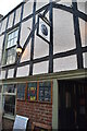
10
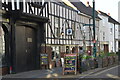
The Thomas Tallis Alehouse
Grade II listed.
Image: © N Chadwick
Taken: 17 Sep 2022
0.02 miles