IMAGES TAKEN NEAR TO
Ellington Road, RAMSGATE, CT11 9SJ
Introduction
This page details the photographs taken nearby to Ellington Road, CT11 9SJ by members of the Geograph project.
The Geograph project started in 2005 with the aim of publishing, organising and preserving representative images for every square kilometre of Great Britain, Ireland and the Isle of Man.

There are currently over 7.5m images from over14,400 individuals and you can help contribute to the project by visiting https://www.geograph.org.uk
Image Map
Images are licensed for reuse under creativecommons.org/licenses/by-sa/2.0
Notes
- Clicking on the map will re-center to the selected point.
- The higher the marker number, the further away the image location is from the centre of the postcode.
Image Listing (171 Images Found)
Images are licensed for reuse under creativecommons.org/licenses/by-sa/2.0
Image
Details
Distance
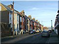
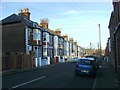
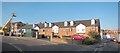
6
Cannon Road, Ramsgate
The south end of Cannon Road, seen from Ellington Road, which becomes Elms Avenue on the right.
Image: © Richard Vince
Taken: 24 Aug 2012
0.06 miles
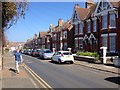
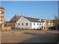
7
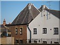
The Maltings, Cannon Road, Ramsgate
Image: © Oast House Archive
Taken: 16 Oct 2011
0.07 miles
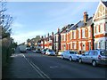
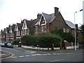
8
Looking NE along Cannon Road
Taken from Ellington Road
Image: © Nick Smith
Taken: 9 Mar 2008
0.07 miles
9
The Maltings, Cannon Road, Ramsgate
Image: © Oast House Archive
Taken: 16 Oct 2011
0.08 miles
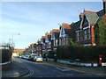
10
The Maltings, Cannon Road, Ramsgate
Image: © Oast House Archive
Taken: 16 Oct 2011
0.08 miles