IMAGES TAKEN NEAR TO
Chapel Place, RAMSGATE, CT11 9SA
Introduction
This page details the photographs taken nearby to Chapel Place, CT11 9SA by members of the Geograph project.
The Geograph project started in 2005 with the aim of publishing, organising and preserving representative images for every square kilometre of Great Britain, Ireland and the Isle of Man.

There are currently over 7.5m images from over14,400 individuals and you can help contribute to the project by visiting https://www.geograph.org.uk
Image Map
Images are licensed for reuse under creativecommons.org/licenses/by-sa/2.0
Notes
- Clicking on the map will re-center to the selected point.
- The higher the marker number, the further away the image location is from the centre of the postcode.
Image Listing (249 Images Found)
Images are licensed for reuse under creativecommons.org/licenses/by-sa/2.0
Image
Details
Distance
1
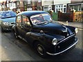
Vintage 1954 Morris Minor, Chapel Place, Ramsgate
Image: © Chris Whippet
Taken: 13 Jan 2016
0.03 miles
2
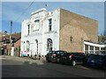
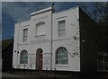
Foresters Hall, Meeting Street, Ramsgate
'Erected MDCCCXI' [1811] and Grade 2 listed. The Foresters were probably a Friendly Society, providing financial help and social benefits for their members.
Image: © Christine Johnstone
Taken: 16 Feb 2022
0.04 miles
4

View of the sea from the hill on Ellington Road
You can just about see the horizon above the tree line in the centre of the image. Notice the strange arrangement of the lamp posts - we have two main road installations, then two side street installations, and then more main road installations following them. Looking south-southeast.
Image: © Robert Lamb
Taken: 21 Aug 2010
0.05 miles
5
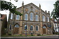
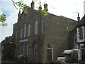
Former church building at the top of Meeting Street
The church was founded in 1662 so it was obviously a dissenting one. The building dates from 1838, but is now used as a dance studio.
Image: © Bill Boaden
Taken: 29 Jun 2012
0.05 miles
6
Foresters Hall
Hall on Meeting Street. Hall has been extended and is now used by Age Concern.
Image: © David Anstiss
Taken: 31 Jul 2010
0.05 miles
7
Former Congregational Church, Ramsgate
Converted Grade II Listed Old United Reformed Church on Meeting Street. Now converted into a warehouse for two businesses; Masque Theatre School and a glass company.
See also http://www.britishlistedbuildings.co.uk/en-171890-former-congregational-church-ramsgate, for more details on the church.
Image: © David Anstiss
Taken: 31 Jul 2010
0.05 miles
9
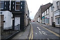
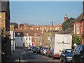
Looking NE along Cannon Road
Taken from Ellington Road
Image: © Nick Smith
Taken: 9 Mar 2008
0.06 miles
10
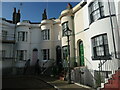
7 - 9 Guildford Lawn, Ramsgate
A terrace of bow-fronted houses, built in 1842. The lawn they once faced is now occupied by a 20th century terrace of houses called Lawn Villas.
Image: © Christine Johnstone
Taken: 16 Feb 2022
0.07 miles