IMAGES TAKEN NEAR TO
Spencer Square, RAMSGATE, CT11 9LA
Introduction
This page details the photographs taken nearby to Spencer Square, CT11 9LA by members of the Geograph project.
The Geograph project started in 2005 with the aim of publishing, organising and preserving representative images for every square kilometre of Great Britain, Ireland and the Isle of Man.

There are currently over 7.5m images from over14,400 individuals and you can help contribute to the project by visiting https://www.geograph.org.uk
Image Map
Images are licensed for reuse under creativecommons.org/licenses/by-sa/2.0
Notes
- Clicking on the map will re-center to the selected point.
- The higher the marker number, the further away the image location is from the centre of the postcode.
Image Listing (344 Images Found)
Images are licensed for reuse under creativecommons.org/licenses/by-sa/2.0
Image
Details
Distance
1
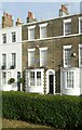
11 Spencer Square, Ramsgate
The blue plaque records that this house was where Vincent Van Gogh lodged while he was teaching at the nearby school in Royal Road https://www.geograph.org.uk/photo/7280438
Image: © Alan Murray-Rust
Taken: 3 Sep 2022
0.02 miles
2
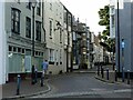
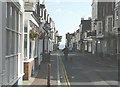
Addington Street, Ramsgate
Part of the major development of the town as a resort in the 1820s and 30s, it included shops as well as houses. Many of the buildings are Listed Grade II.
Image: © Alan Murray-Rust
Taken: 3 Sep 2022
0.02 miles
3
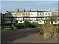
Spencer Square, north east side, Ramsgate
This side of the square was developed by James Townley in the 1830s, replacing barracks that had been developed during the Napoleonic wars. Listed Grade II as a complete terrace.
Image: © Alan Murray-Rust
Taken: 3 Sep 2022
0.02 miles
5
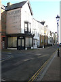
Looking east-southeast along Addington Street
On the left, number 36B has its ground floor windows covered by closed Venetian blinds. Faded signage, on the side of the address, indicates it once belonged to Pickfords.
Image: © John Baker
Taken: 16 Feb 2016
0.02 miles
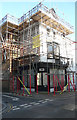
6
Looking west-northwest along Addington Street
On the left, number 31 has had scaffolding erected on its frontage.
Image: © John Baker
Taken: 16 Feb 2016
0.03 miles
7
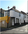
36B, Addington Street
This shop used to be an outlet of Pickfords as there is a ghost sign under the scaffolding on the wall above Hertford Place, where there appears to be another entrance to 36B. This number, letter and an arrow has been painted on the wall to the right of the grey door.
Image: © John Baker
Taken: 22 Mar 2020
0.03 miles
8
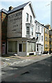
36B, Addington Street
The side of the building clearly shows ghost writing in the form of Pickfords furniture removals and storage. This was partly hidden in a previous view of Image
Image: © John Baker
Taken: 18 Apr 2021
0.03 miles
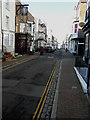
9
Addington Street, Ramsgate
Looking in the direction of the sea.
Image: © John Baker
Taken: 12 Oct 2009
0.03 miles
10
41, Addington Street
Planning permission has been granted by Thanet District Council under application number L/TH/19/1646 for an “application for listed building consent for the replacement of bay window to front elevation together with internal works”. This was Image after the work had been completed.
The house, which was once a shop, is grade II listed and dates from 1801-21 https://britishlistedbuildings.co.uk/101186878-41-addington-street-ramsgate#.XqHbef5Ybcc
Image: © John Baker
Taken: 22 Mar 2020
0.03 miles