IMAGES TAKEN NEAR TO
Townley Street, RAMSGATE, CT11 9JU
Introduction
This page details the photographs taken nearby to Townley Street, CT11 9JU by members of the Geograph project.
The Geograph project started in 2005 with the aim of publishing, organising and preserving representative images for every square kilometre of Great Britain, Ireland and the Isle of Man.

There are currently over 7.5m images from over14,400 individuals and you can help contribute to the project by visiting https://www.geograph.org.uk
Image Map
Images are licensed for reuse under creativecommons.org/licenses/by-sa/2.0
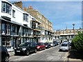
Notes
- Clicking on the map will re-center to the selected point.
- The higher the marker number, the further away the image location is from the centre of the postcode.
Image Listing (320 Images Found)
Images are licensed for reuse under creativecommons.org/licenses/by-sa/2.0
Image
Details
Distance
3
23, Addington Street
It appears that this address was once a shop but all traces of the signage has disappeared; it is seen from Albert Street.
Image: © John Baker
Taken: 15 Sep 2015
0.03 miles
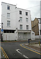
4
27, Addington Street
It is a grade II listed building that was once a house and shop dating from around 1830, that was originally two separate buildings. In this view, it can be seen that the one on the left is three storeys and the one on the right, with two storeys, has a parapet above the first floor window. The shop window (now covered with white-painted boards) was fitted with 19th century plate glass
http://www.britishlistedbuildings.co.uk/en-171662-27-addington-street-ramsgate-kent#.VhVm4MKFPcc
Image: © John Baker
Taken: 15 Sep 2015
0.03 miles
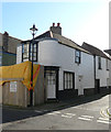
6
41, Addington Street
The view shows the bay window, on the ground floor, which was being installed when the view of Image was photographed.
Image: © John Baker
Taken: 18 Apr 2021
0.04 miles
8
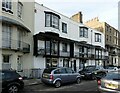
25 ? 37 Spencer Square, Ramsgate
Part of the early development of the square in the earliest years of the 19th century (c.1804) originally used as officers' quarters for the adjacent barracks when Ramsgate was a major departure point for forces heading across the Channel during the Napoleonic War. The designer was Mary Townley, wife of the owner and developer of the square. Now a small hotel. Listed Grade II.
Image: © Alan Murray-Rust
Taken: 3 Sep 2022
0.04 miles
10
41, Addington Street
Planning permission has been granted by Thanet District Council under application number L/TH/19/1646 for an “application for listed building consent for the replacement of bay window to front elevation together with internal works”. This was Image after the work had been completed.
The house, which was once a shop, is grade II listed and dates from 1801-21 https://britishlistedbuildings.co.uk/101186878-41-addington-street-ramsgate#.XqHbef5Ybcc
Image: © John Baker
Taken: 22 Mar 2020
0.04 miles