IMAGES TAKEN NEAR TO
Queen Street, CT11 9DH
Introduction
This page details the photographs taken nearby to Queen Street, CT11 9DH by members of the Geograph project.
The Geograph project started in 2005 with the aim of publishing, organising and preserving representative images for every square kilometre of Great Britain, Ireland and the Isle of Man.

There are currently over 7.5m images from over14,400 individuals and you can help contribute to the project by visiting https://www.geograph.org.uk
Image Map
Images are licensed for reuse under creativecommons.org/licenses/by-sa/2.0
Notes
- Clicking on the map will re-center to the selected point.
- The higher the marker number, the further away the image location is from the centre of the postcode.
Image Listing (429 Images Found)
Images are licensed for reuse under creativecommons.org/licenses/by-sa/2.0
Image
Details
Distance
1
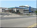
Derelict petrol station, West Cliff Road
This used to be a Total UK Ltd premises.
Image: © John Baker
Taken: 7 Jul 2013
0.01 miles
2
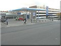
Hand Car Wash, West Cliff Road
The site has been given a new lease of life, as before it was a Image
Image: © John Baker
Taken: 19 Nov 2013
0.02 miles
3
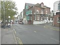
94, Queen Street
This is the house with scaffolding covering its frontage (which overlooks Hertford Street) and side.
Image: © John Baker
Taken: 9 Nov 2014
0.03 miles
4
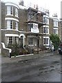
8, Vale Square
Planning permission was granted by Thanet District Council under application number L/TH/17/1298 for an “application for listed building consent for replacement sash windows on ground floor and repairs to remaining existing windows, repairs to external render and repointing together with internal alterations and repairs including installation of steel support to basement and backfilling of deep shaft to rear of property”.
Image: © John Baker
Taken: 31 Dec 2017
0.05 miles
5
3, Vale Square
The house appears to be undergoing renovation.
Planning permission has been granted by Thanet District Council under application number F/TH/17/1740 for the “erection of 1m high railings to front elevation following demolition of existing boundary wall”. This application also relates to numbers 1 and 2.
Image: © John Baker
Taken: 31 Dec 2017
0.06 miles
8
Looking north-northwest along Vale Square
On the right, number 4 has had scaffolding erected on its frontage.
Image: © John Baker
Taken: 16 Feb 2016
0.07 miles
9

Renovation of Chatham & Clarendon Grammar School
The school, also known as Clarendon House, is located in Clarendon Gardens.
Image: © John Baker
Taken: 2 Jan 2017
0.07 miles
10
1, Archway Road
Thanet District Council has granted permission under application number F/TH/13/0694 for the “change of use of building to provide eight 1-bed flats and three 2-bed flats, together with a roof extension for the second floor accommodation”. This side of the building is engraved with the words and number “established 1817 merchants”.
However this was superseded by the planning permission, which was granted by Thanet District Council under application number F/TH/17/0127 for the “erection of a 3-storey building containing 3 1-bed flats to side of 1 Archway Road following demolition of existing garage”.
Image: © John Baker
Taken: 23 Oct 2016
0.07 miles